Ikorodu geodata
Ikorodu (Lagos) is a seat of a second-order administrative division; located in Nigeria in Africa/Lagos (GMT+1) time zone. In our database, there are 451 cities with bigger population. Compared to other cities in Nigeria, 74.3% of cities are located further ↑North; 95.1% of cities are located further →East and 89.2% of cities have higher elevation than Ikorodu. Note1


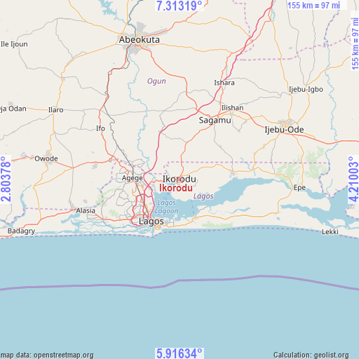
Ikorodu GPS coordinates[2]
6° 36' 54.936" North, 3° 30' 24.84" East
| Map corner | latitude | longitude |
|---|---|---|
| Upper-left | 7.31319°, | 2.80378° |
| Center: | 6.61526°, | 3.5069° |
| Lower-right: | 5.91634°, | 4.21003° |
| Map W x H: | 155.3×155.3 km | = 96.5×96.5mi |
| max Lat: | 13.7543° ⇑74.3% North |
| Ikorodu: | 6.61526° |
| min Lat: | ⇓25.7% South 4.31231° |
| min Long | Ikorodu | max Long |
| 2.73333° | 3.5069° | 14.46552° |
| W 4.9%⇐ | ⇒95.1% E |
Elevation
Elevation of Ikorodu is 36 m = 118 ft, and this is 260.5 m = 855 ft below average elevation for this country.
| Max E: |
1599 m = 5246 ft | 89.2% |
| Avg. | 296.5 m = 973 ft | |
| Ikorodu | 36 m = 118 ft | |
Min E: |
2 m = 7 ft | 10.8% |
See also: Nigeria elevation on elevation.city.
Geographical zone
Ikorodu is located in North Torrid zone (between Equator and Tropic of Cancer). Distance of Equator is 735.5 km =457 mi to South.| Distance of | km | miles | from Ikorodu |
|---|---|---|---|
| North Pole | 9271.5 | 5761 | to North |
| Arctic Circle | 6665.6 | 4141.8 | to North |
| Tropic Cancer | 1870.4 | 1162.2 | to North |
| Equator | 735.5 | 457 | to South |


Nearby cities:
15 places around Ikorodu: (largest is in red/bold)
• Agege
19.2 km =11.9 mi,  270°
270°
• Ajegunle
26.6 km =16.5 mi,  226°
226°
• Apapa
24.7 km =15.3 mi,  221°
221°
• Ebute Ikorodu
2.6 km =1.6 mi, 232°
• Ebute-Metta
19.8 km =12.3 mi, 224°
• Ifako
20.4 km =12.7 mi,  279°
279°
• Ikeja
18.3 km =11.4 mi,  263°
263°
• Ikoyi
19.7 km =12.2 mi,  203°
203°
• Lagos
21.8 km =13.5 mi,  214°
214°
• Makoko
18.7 km =11.6 mi, 224°
• Mushin
19.5 km =12.1 mi,  240°
240°
• Ojota
13.9 km =8.6 mi,  252°
252°
• Oshodi
19.2 km =11.9 mi, 249°
• Somolu
16.9 km =10.5 mi, 239°
• Surulere
20.7 km =12.9 mi, 232°
Sources, notices
• [Note1] Compared only with cities in Nigeria existing in our database
• [Src1] Map data: © OpenStreetMap contributors (CC-BY-SA)
• [Src2] Other city data from geonames.org with taken over terms of usage.
• [Src3] Geographical zone / Annual Mean Temperature by Robert A. Rohde @ Wikipedia
