Ebute Ikorodu geodata
Ebute Ikorodu (Lagos) is a populated place; located in Nigeria in Africa/Lagos (GMT+1) time zone. With population of 535,619 people, there are 18 cities with bigger population in this country. Compared to other cities in Nigeria, 74.6% of cities are located further ↑North; 95.5% of cities are located further →East and 99.7% of cities have higher elevation than Ebute Ikorodu. Note1


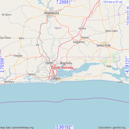
Ebute Ikorodu GPS coordinates[2]
6° 36' 3.096" North, 3° 29' 17.448" East
| Map corner | latitude | longitude |
|---|---|---|
| Upper-left | 7.29881°, | 2.78506° |
| Center: | 6.60086°, | 3.48818° |
| Lower-right: | 5.90192°, | 4.19131° |
| Map W x H: | 155.3×155.3 km | = 96.5×96.5mi |
| max Lat: | 13.7543° ⇑74.6% North |
| Ebute Ikorodu: | 6.60086° |
| min Lat: | ⇓25.4% South 4.31231° |
| min Long | Ebute Ikorodu | max Long |
| 2.73333° | 3.48818° | 14.46552° |
| W 4.5%⇐ | ⇒95.5% E |
Elevation
Elevation of Ebute Ikorodu is 4 m = 13 ft, and this is 292.5 m = 960 ft below average elevation for this country.
| Max E: |
1599 m = 5246 ft | 99.7% |
| Avg. | 296.5 m = 973 ft | |
| Ebute Ikorodu | 4 m = 13 ft | |
Min E: |
2 m = 7 ft | 0.3% |
See also: Ebute Ikorodu elevation on elevation.city.
Geographical zone
Ebute Ikorodu is located in North Torrid zone (between Equator and Tropic of Cancer). Distance of Equator is 733.9 km =456 mi to South.| Distance of | km | miles | from Ebute Ikorodu |
|---|---|---|---|
| North Pole | 9273.1 | 5762 | to North |
| Arctic Circle | 6667.2 | 4142.8 | to North |
| Tropic Cancer | 1872 | 1163.2 | to North |
| Equator | 733.9 | 456 | to South |


Nearby cities:
15 places around Ebute Ikorodu: (largest is in red/bold)
• Agege
17.2 km =10.7 mi,  275°
275°
• Ajegunle
24 km =14.9 mi,  226°
226°
• Apapa
22.1 km =13.7 mi,  220°
220°
• Ebute-Metta
17.2 km =10.7 mi, 223°
• Ifako
18.7 km =11.6 mi, 284°
• Ikeja
16.1 km =10 mi,  268°
268°
• Ikorodu
2.6 km =1.6 mi,  52°
52°
• Ikoyi
17.5 km =10.9 mi,  199°
199°
• Lagos
19.3 km =12 mi,  212°
212°
• Makoko
16.1 km =10 mi, 223°
• Mushin
16.9 km =10.5 mi,  241°
241°
• Ojota
11.5 km =7.1 mi,  257°
257°
• Oshodi
16.8 km =10.4 mi,  252°
252°
• Somolu
14.4 km =8.9 mi, 241°
• Surulere
18.1 km =11.2 mi, 232°
Sources, notices
• [Note1] Compared only with cities in Nigeria existing in our database
• [Src1] Map data: © OpenStreetMap contributors (CC-BY-SA)
• [Src2] Other city data from geonames.org with taken over terms of usage.
• [Src3] Geographical zone / Annual Mean Temperature by Robert A. Rohde @ Wikipedia
