Badagry geodata
Badagry (Lagos) is a seat of a second-order administrative division; located in Nigeria in Africa/Lagos (GMT+1) time zone. With population of 26,383 people, there are 171 cities with bigger population in this country. Compared to other cities in Nigeria, 78.3% of cities are located further ↑North; 99.7% of cities are located further →East and 99.4% of cities have higher elevation than Badagry. Note1


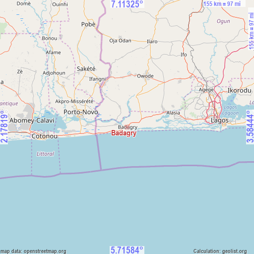
Badagry GPS coordinates[2]
6° 24' 54.072" North, 2° 52' 52.752" East
| Map corner | latitude | longitude |
|---|---|---|
| Upper-left | 7.11325°, | 2.17819° |
| Center: | 6.41502°, | 2.88132° |
| Lower-right: | 5.71584°, | 3.58444° |
| Map W x H: | 155.4×155.4 km | = 96.6×96.6mi |
| max Lat: | 13.7543° ⇑78.3% North |
| Badagry: | 6.41502° |
| min Lat: | ⇓21.7% South 4.31231° |
| min Long | Badagry | max Long |
| 2.73333° | 2.88132° | 14.46552° |
| W 0.3%⇐ | ⇒99.7% E |
Elevation
Elevation of Badagry is 5 m = 16 ft, and this is 291.5 m = 956 ft below average elevation for this country.
| Max E: |
1599 m = 5246 ft | 99.4% |
| Avg. | 296.5 m = 973 ft | |
| Badagry | 5 m = 16 ft | |
Min E: |
2 m = 7 ft | 0.6% |
See also: Nigeria elevation on elevation.city.
Geographical zone
Badagry is located in North Torrid zone (between Equator and Tropic of Cancer). Distance of Equator is 713.3 km =443.2 mi to South.| Distance of | km | miles | from Badagry |
|---|---|---|---|
| North Pole | 9293.8 | 5774.9 | to North |
| Arctic Circle | 6687.9 | 4155.7 | to North |
| Tropic Cancer | 1892.6 | 1176 | to North |
| Equator | 713.3 | 443.2 | to South |


Nearby cities:
15 places around Badagry: (largest is in red/bold)
• Ado Odo
21.4 km =13.3 mi,  15°
15°
• Agege
54.7 km =34 mi,  65°
65°
• Ajegunle
49.9 km =31 mi,  85°
85°
• Apapa
52.9 km =32.9 mi, 85°
• Festac Town
44.8 km =27.8 mi,  82°
82°
• Idi Iroko
29.3 km =18.2 mi,  326°
326°
• Ifako
55.2 km =34.3 mi,  62°
62°
• Ikeja
54.8 km =34.1 mi, 68°
• Ikotun
44.6 km =27.7 mi, 71°
• Ilaro
54.7 km =34 mi, 15°
• Ipokia
13 km =8.1 mi,  340°
340°
• Mushin
53.7 km =33.4 mi, 76°
• Oshodi
53.4 km =33.2 mi, 73°
• Ota
49.3 km =30.6 mi,  51°
51°
• Surulere
53.5 km =33.2 mi, 79°
Sources, notices
• [Note1] Compared only with cities in Nigeria existing in our database
• [Src1] Map data: © OpenStreetMap contributors (CC-BY-SA)
• [Src2] Other city data from geonames.org with taken over terms of usage.
• [Src3] Geographical zone / Annual Mean Temperature by Robert A. Rohde @ Wikipedia
