Ilaro geodata
Ilaro (Ogun) is a seat of a second-order administrative division; located in Nigeria in Africa/Lagos (GMT+1) time zone. With population of 46,999 people, there are 148 cities with bigger population in this country. Compared to other cities in Nigeria, 69.9% of cities are located further ↑North; 99.4% of cities are located further →East and 81.8% of cities have higher elevation than Ilaro. Note1


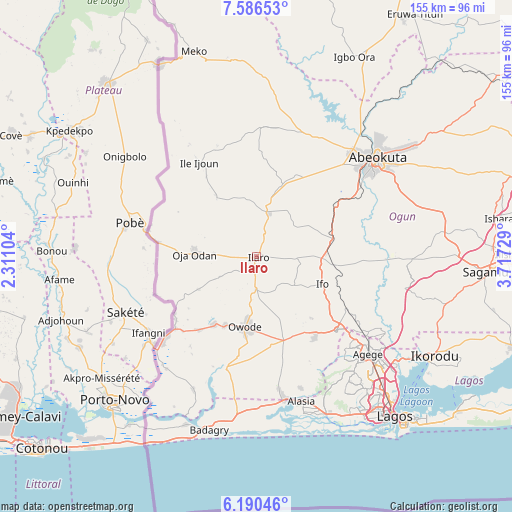
Ilaro GPS coordinates[2]
6° 53' 20.436" North, 3° 0' 50.976" East
| Map corner | latitude | longitude |
|---|---|---|
| Upper-left | 7.58653°, | 2.31104° |
| Center: | 6.88901°, | 3.01416° |
| Lower-right: | 6.19046°, | 3.71729° |
| Map W x H: | 155.2×155.2 km | = 96.4×96.4mi |
| max Lat: | 13.7543° ⇑69.9% North |
| Ilaro: | 6.88901° |
| min Lat: | ⇓30.1% South 4.31231° |
| min Long | Ilaro | max Long |
| 2.73333° | 3.01416° | 14.46552° |
| W 0.6%⇐ | ⇒99.4% E |
Elevation
Elevation of Ilaro is 73 m = 240 ft, and this is 223.5 m = 733 ft below average elevation for this country.
| Max E: |
1599 m = 5246 ft | 81.8% |
| Avg. | 296.5 m = 973 ft | |
| Ilaro | 73 m = 240 ft | |
Min E: |
2 m = 7 ft | 18.2% |
See also: Ilaro elevation on elevation.city.
Geographical zone
Ilaro is located in North Torrid zone (between Equator and Tropic of Cancer). Distance of Equator is 766 km =476 mi to South.| Distance of | km | miles | from Ilaro |
|---|---|---|---|
| North Pole | 9241.1 | 5742.2 | to North |
| Arctic Circle | 6635.2 | 4122.9 | to North |
| Tropic Cancer | 1839.9 | 1143.3 | to North |
| Equator | 766 | 476 | to South |


Nearby cities:
15 places around Ilaro: (largest is in red/bold)
• Abeokuta
47 km =29.2 mi,  50°
50°
• Ado Odo
33.4 km =20.8 mi,  195°
195°
• Agege
46.5 km =28.9 mi,  130°
130°
• Ayetoro
39.4 km =24.5 mi,  1°
1°
• Idi Iroko
42.1 km =26.2 mi,  227°
227°
• Ifako
43.8 km =27.2 mi, 128°
• Ifo
21.6 km =13.4 mi,  112°
112°
• Ikeja
48.7 km =30.3 mi, 131°
• Ikotun
47.2 km =29.3 mi,  144°
144°
• Ipokia
44.7 km =27.8 mi,  205°
205°
• Itori
23.4 km =14.5 mi,  78°
78°
• Ojota
53.8 km =33.4 mi, 130°
• Oshodi
52 km =32.3 mi, 135°
• Ota
32.8 km =20.4 mi, 132°
• Owode
54.6 km =33.9 mi, 83°
Sources, notices
• [Note1] Compared only with cities in Nigeria existing in our database
• [Src1] Map data: © OpenStreetMap contributors (CC-BY-SA)
• [Src2] Other city data from geonames.org with taken over terms of usage.
• [Src3] Geographical zone / Annual Mean Temperature by Robert A. Rohde @ Wikipedia
