Matagalpa geodata
Matagalpa is a seat of a first-order administrative division; located in Nicaragua in America/Managua (GMT-6) time zone. With population of 109,089 people, there are 4 cities with bigger population in this country. Compared to other cities in Nicaragua, 63.5% of cities are located further ↓South; 58.7% of cities are located further ←West and 86.2% of cities have lower elevation than Matagalpa. Note1


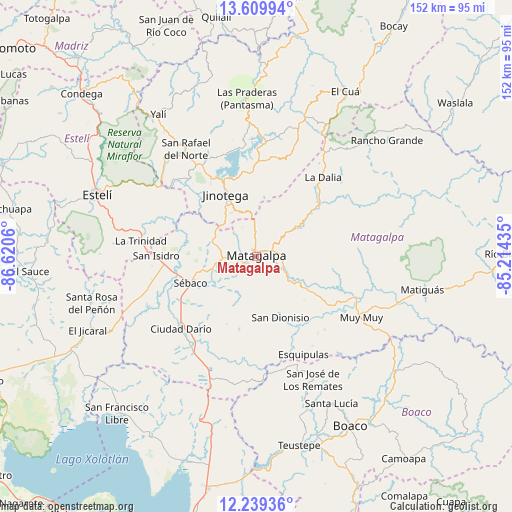
Matagalpa GPS coordinates[2]
12° 55' 32.124" North, 85° 55' 2.892" West
| Map corner | latitude | longitude |
|---|---|---|
| Upper-left | 13.60994°, | -86.6206° |
| Center: | 12.92559°, | -85.91747° |
| Lower-right: | 12.23936°, | -85.21435° |
| Map W x H: | 152.4×152.4 km | = 94.7×94.7mi |
| max Lat: | 14.74189° ⇑36.5% North |
| Matagalpa: | 12.92559° |
| min Lat: | ⇓63.5% South 10.94684° |
| min Long | Matagalpa | max Long |
| -87.4516° | -85.91747° | -83.06145° |
| W 58.7%⇐ | ⇒41.3% E |
Elevation
Elevation of Matagalpa is 686 m = 2251 ft, and this is 348.8 m = 1144 ft above average elevation for this country.
| Max E: |
1288 m = 4226 ft | 13.8% |
| Matagalpa | 686 m 2251 ft | |
| Avg. | 337.2 m = 1106 ft | |
Min E: |
1 m = 3 ft | 86.2% |
See also: Matagalpa elevation on elevation.city.
Geographical zone
Matagalpa is located in North Torrid zone (between Equator and Tropic of Cancer). Distance of this Northern Tropic circle is 1168.7 km =726.2 mi to North.| Distance of | km | miles | from Matagalpa |
|---|---|---|---|
| North Pole | 8569.9 | 5325.1 | to North |
| Arctic Circle | 5964 | 3705.9 | to North |
| Tropic Cancer | 1168.7 | 726.2 | to North |
| Equator | 1437.2 | 893 | to South |


Nearby cities:
15 places around Matagalpa: (largest is in red/bold)
• Ciudad Darío
31.1 km =19.3 mi,  226°
226°
• Esquipulas
32.3 km =20.1 mi,  154°
154°
• Jinotega
20.6 km =12.8 mi,  333°
333°
• LLano de La Cruz
24.2 km =15 mi,  336°
336°
• La Dalia
30.5 km =19 mi,  39°
39°
• La Trinidad
34.8 km =21.6 mi,  277°
277°
• Las Praderas
28.1 km =17.5 mi,  15°
15°
• Muy Muy
36.2 km =22.5 mi,  120°
120°
• San Dionisio
19.8 km =12.3 mi,  158°
158°
• San Isidro
30.1 km =18.7 mi,  270°
270°
• San José de los Remates
40.2 km =25 mi, 155°
• San Rafael del Norte
38.2 km =23.7 mi, 326°
• San Ramón
8.5 km =5.3 mi,  91°
91°
• Sébaco
21 km =13 mi,  247°
247°
• Terrabona
22.3 km =13.9 mi,  193°
193°
Sources, notices
• [Note1] Compared only with cities in Nicaragua existing in our database
• [Src1] Map data: © OpenStreetMap contributors (CC-BY-SA)
• [Src2] Other city data from geonames.org with taken over terms of usage.
• [Src3] Geographical zone / Annual Mean Temperature by Robert A. Rohde @ Wikipedia
