Jinotega geodata
Jinotega is a seat of a first-order administrative division; located in Nicaragua in America/Managua (GMT-6) time zone. With population of 55,000 people, there are 7 cities with bigger population in this country. Compared to other cities in Nicaragua, 68.9% of cities are located further ↓South; 55.7% of cities are located further ←West and 98.2% of cities have lower elevation than Jinotega. Note1


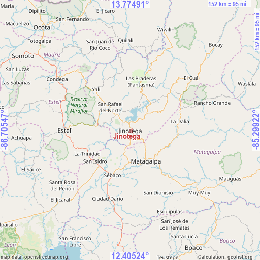
Jinotega GPS coordinates[2]
13° 5' 27.708" North, 86° 0' 8.424" West
| Map corner | latitude | longitude |
|---|---|---|
| Upper-left | 13.77491°, | -86.70547° |
| Center: | 13.09103°, | -86.00234° |
| Lower-right: | 12.40524°, | -85.29922° |
| Map W x H: | 152.3×152.3 km | = 94.6×94.6mi |
| max Lat: | 14.74189° ⇑31.1% North |
| Jinotega: | 13.09103° |
| min Lat: | ⇓68.9% South 10.94684° |
| min Long | Jinotega | max Long |
| -87.4516° | -86.00234° | -83.06145° |
| W 55.7%⇐ | ⇒44.3% E |
Elevation
Elevation of Jinotega is 1020 m = 3346 ft, and this is 682.8 m = 2240 ft above average elevation for this country.
| Max E: |
1288 m = 4226 ft | 1.8% |
| Jinotega | 1020 m 3346 ft | |
| Avg. | 337.2 m = 1106 ft | |
Min E: |
1 m = 3 ft | 98.2% |
See also: Jinotega elevation on elevation.city.
Geographical zone
Jinotega is located in North Torrid zone (between Equator and Tropic of Cancer). Distance of this Northern Tropic circle is 1150.3 km =714.8 mi to North.| Distance of | km | miles | from Jinotega |
|---|---|---|---|
| North Pole | 8551.5 | 5313.7 | to North |
| Arctic Circle | 5945.6 | 3694.4 | to North |
| Tropic Cancer | 1150.3 | 714.8 | to North |
| Equator | 1455.6 | 904.5 | to South |


Nearby cities:
15 places around Jinotega: (largest is in red/bold)
• Estelí
38.1 km =23.7 mi,  270°
270°
• LLano de La Cruz
3.8 km =2.4 mi,  350°
350°
• La Concordia
21.2 km =13.2 mi,  303°
303°
• La Dalia
29.1 km =18.1 mi,  80°
80°
• La Trinidad
28.7 km =17.8 mi,  241°
241°
• Las Praderas
18.7 km =11.6 mi,  61°
61°
• Matagalpa
20.6 km =12.8 mi,  153°
153°
• San Dionisio
40.3 km =25 mi,  155°
155°
• San Isidro
27.5 km =17.1 mi,  229°
229°
• San Rafael del Norte
17.9 km =11.1 mi,  318°
318°
• San Ramón
25.7 km =16 mi,  136°
136°
• San Sebastián de Yalí
31.1 km =19.3 mi, 320°
• Santa Maía de Pantasma
29.3 km =18.2 mi,  12°
12°
• Sébaco
28.3 km =17.6 mi,  201°
201°
• Terrabona
40.3 km =25 mi,  174°
174°
Sources, notices
• [Note1] Compared only with cities in Nicaragua existing in our database
• [Src1] Map data: © OpenStreetMap contributors (CC-BY-SA)
• [Src2] Other city data from geonames.org with taken over terms of usage.
• [Src3] Geographical zone / Annual Mean Temperature by Robert A. Rohde @ Wikipedia
