Zoelmond geodata
Zoelmond (Gelderland) is a populated place; located in Netherlands in Europe/Amsterdam (GMT+2) time zone. With population of 550 people, there are 1777 cities with bigger population in this country. Compared to other cities in Netherlands, 54.7% of cities are located further ↑North; 63.1% of cities are located further →East and 52.4% of cities have lower elevation than Zoelmond. Note1


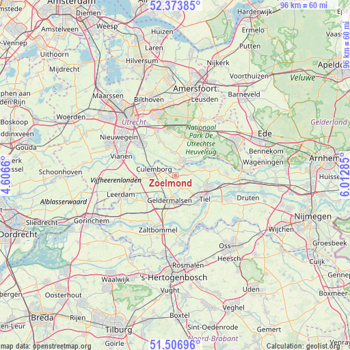
Zoelmond GPS coordinates[2]
51° 56' 33" North, 5° 18' 34.992" East
| Map corner | latitude | longitude |
|---|---|---|
| Upper-left | 52.37385°, | 4.6066° |
| Center: | 51.9425°, | 5.30972° |
| Lower-right: | 51.50696°, | 6.01285° |
| Map W x H: | 96.4×96.4 km | = 59.9×59.9mi |
| max Lat: | 53.48025° ⇑54.7% North |
| Zoelmond: | 51.9425° |
| min Lat: | ⇓45.3% South 50.76917° |
| min Long | Zoelmond | max Long |
| 3.38611° | 5.30972° | 7.16528° |
| W 36.9%⇐ | ⇒63.1% E |
Elevation
Elevation of Zoelmond is 7 m = 23 ft, and this is 8 m = 26 ft below average elevation for this country.
| Max E: |
203 m = 666 ft | 47.6% |
| Avg. | 15 m = 49 ft | |
| Zoelmond | 7 m = 23 ft | |
Min E: |
-6 m = -20 ft | 52.4% |
See also: Netherlands elevation on elevation.city.
Geographical zone
Zoelmond is located in North temperate zone (between Tropic of Cancer and the Arctic Circle). Distance of this North polar circle is 1625.7 km =1010.2 mi to North.| Distance of | km | miles | from Zoelmond |
|---|---|---|---|
| North Pole | 4231.6 | 2629.4 | to North |
| Arctic Circle | 1625.7 | 1010.2 | to North |
| Tropic Cancer | 3169.5 | 1969.4 | to South |
| Equator | 5775.5 | 3588.7 | to South |


Nearby cities:
15 places around Zoelmond: (largest is in red/bold)
• Beesd
10.1 km =6.3 mi,  232°
232°
• Beusichem
1.5 km =0.9 mi,  303°
303°
• Buurmalsen
5.7 km =3.5 mi,  190°
190°
• Cothen
6 km =3.7 mi,  359°
359°
• Culemborg
5.8 km =3.6 mi,  283°
283°
• Deil
7.9 km =4.9 mi,  215°
215°
• Drumpt
8.6 km =5.3 mi,  126°
126°
• Geldermalsen
7 km =4.3 mi, 191°
• Geldermalsen-West
7.3 km =4.5 mi,  196°
196°
• Maurik
8 km =5 mi,  75°
75°
• Meteren
8.8 km =5.5 mi, 191°
• Tricht
6.4 km =4 mi,  206°
206°
• Wadenoijen
8.7 km =5.4 mi,  150°
150°
• Wijk bij Duurstede
4.1 km =2.5 mi,  31°
31°
• Zoelen
7.2 km =4.5 mi,  117°
117°
Sources, notices
• [Note1] Compared only with cities in Netherlands existing in our database
• [Src1] Map data: © OpenStreetMap contributors (CC-BY-SA)
• [Src2] Other city data from geonames.org with taken over terms of usage.
• [Src3] Geographical zone / Annual Mean Temperature by Robert A. Rohde @ Wikipedia
