Wadenoijen geodata
Wadenoijen (Gelderland) is a populated place; located in Netherlands in Europe/Amsterdam (GMT+2) time zone. With population of 720 people, there are 1602 cities with bigger population in this country. Compared to other cities in Netherlands, 60% of cities are located further ↑North; 61.7% of cities are located further →East and 58.8% of cities have higher elevation than Wadenoijen. Note1


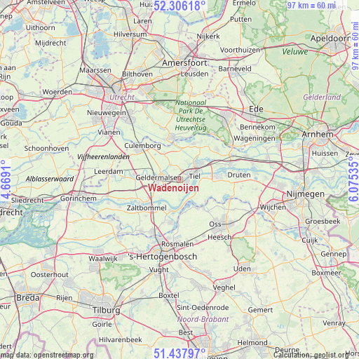
Wadenoijen GPS coordinates[2]
51° 52' 27.012" North, 5° 22' 19.992" East
| Map corner | latitude | longitude |
|---|---|---|
| Upper-left | 52.30618°, | 4.6691° |
| Center: | 51.87417°, | 5.37222° |
| Lower-right: | 51.43797°, | 6.07535° |
| Map W x H: | 96.5×96.5 km | = 60×60mi |
| max Lat: | 53.48025° ⇑60% North |
| Wadenoijen: | 51.87417° |
| min Lat: | ⇓40% South 50.76917° |
| min Long | Wadenoijen | max Long |
| 3.38611° | 5.37222° | 7.16528° |
| W 38.3%⇐ | ⇒61.7% E |
Elevation
Elevation of Wadenoijen is 4 m = 13 ft, and this is 11 m = 36 ft below average elevation for this country.
| Max E: |
203 m = 666 ft | 58.8% |
| Avg. | 15 m = 49 ft | |
| Wadenoijen | 4 m = 13 ft | |
Min E: |
-6 m = -20 ft | 41.2% |
See also: Netherlands elevation on elevation.city.
Geographical zone
Wadenoijen is located in North temperate zone (between Tropic of Cancer and the Arctic Circle). Distance of this North polar circle is 1633.3 km =1014.9 mi to North.| Distance of | km | miles | from Wadenoijen |
|---|---|---|---|
| North Pole | 4239.2 | 2634.1 | to North |
| Arctic Circle | 1633.3 | 1014.9 | to North |
| Tropic Cancer | 3161.9 | 1964.7 | to South |
| Equator | 5767.9 | 3584 | to South |


Nearby cities:
15 places around Wadenoijen: (largest is in red/bold)
• Buurmalsen
5.7 km =3.5 mi,  290°
290°
• Drumpt
3.6 km =2.2 mi,  45°
45°
• Geldermalsen
5.8 km =3.6 mi,  277°
277°
• Geldermalsen-West
6.3 km =3.9 mi, 275°
• Heerewaarden
6.4 km =4 mi,  167°
167°
• Hurwenen
8 km =5 mi,  208°
208°
• Meteren
6.2 km =3.9 mi,  260°
260°
• Ophemert
3.4 km =2.1 mi,  162°
162°
• Opijnen
7.1 km =4.4 mi,  225°
225°
• Rossum
8.6 km =5.3 mi,  198°
198°
• Tiel
4.1 km =2.5 mi,  70°
70°
• Tricht
7.4 km =4.6 mi, 284°
• Varik
5.7 km =3.5 mi,  180°
180°
• Zoelen
4.7 km =2.9 mi,  26°
26°
• Zoelmond
8.7 km =5.4 mi,  330°
330°
Sources, notices
• [Note1] Compared only with cities in Netherlands existing in our database
• [Src1] Map data: © OpenStreetMap contributors (CC-BY-SA)
• [Src2] Other city data from geonames.org with taken over terms of usage.
• [Src3] Geographical zone / Annual Mean Temperature by Robert A. Rohde @ Wikipedia
