Deil geodata
Deil (Gelderland) is a populated place; located in Netherlands in Europe/Amsterdam (GMT+2) time zone. With population of 1,880 people, there are 1002 cities with bigger population in this country. Compared to other cities in Netherlands, 59.2% of cities are located further ↑North; 65.2% of cities are located further →East and 65.8% of cities have higher elevation than Deil. Note1


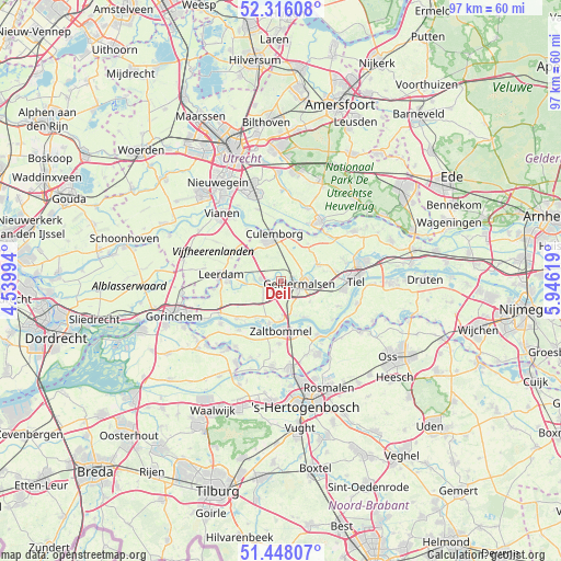
Deil GPS coordinates[2]
51° 53' 3.012" North, 5° 14' 35.016" East
| Map corner | latitude | longitude |
|---|---|---|
| Upper-left | 52.31608°, | 4.53994° |
| Center: | 51.88417°, | 5.24306° |
| Lower-right: | 51.44807°, | 5.94619° |
| Map W x H: | 96.5×96.5 km | = 60×60mi |
| max Lat: | 53.48025° ⇑59.2% North |
| Deil: | 51.88417° |
| min Lat: | ⇓40.8% South 50.76917° |
| min Long | Deil | max Long |
| 3.38611° | 5.24306° | 7.16528° |
| W 34.8%⇐ | ⇒65.2% E |
Elevation
Elevation of Deil is 3 m = 10 ft, and this is 12 m = 39 ft below average elevation for this country.
| Max E: |
203 m = 666 ft | 65.8% |
| Avg. | 15 m = 49 ft | |
| Deil | 3 m = 10 ft | |
Min E: |
-6 m = -20 ft | 34.2% |
See also: Netherlands elevation on elevation.city.
Geographical zone
Deil is located in North temperate zone (between Tropic of Cancer and the Arctic Circle). Distance of this North polar circle is 1632.2 km =1014.2 mi to North.| Distance of | km | miles | from Deil |
|---|---|---|---|
| North Pole | 4238.1 | 2633.4 | to North |
| Arctic Circle | 1632.2 | 1014.2 | to North |
| Tropic Cancer | 3163.1 | 1965.5 | to South |
| Equator | 5769 | 3584.7 | to South |


Nearby cities:
15 places around Deil: (largest is in red/bold)
• Beesd
3.5 km =2.2 mi,  275°
275°
• Beusichem
8 km =5 mi,  24°
24°
• Buurmalsen
3.6 km =2.2 mi,  76°
76°
• Culemborg
7.9 km =4.9 mi,  352°
352°
• Geldermalsen
3.2 km =2 mi,  96°
96°
• Geldermalsen-West
2.6 km =1.6 mi, 101°
• Haaften
7.9 km =4.9 mi,  196°
196°
• Hellouw
7.9 km =4.9 mi,  215°
215°
• Meteren
3.5 km =2.2 mi,  127°
127°
• Opijnen
7.2 km =4.5 mi,  148°
148°
• Rhenoy
6.2 km =3.9 mi,  269°
269°
• Rumpt
4.6 km =2.9 mi, 270°
• Tricht
1.9 km =1.2 mi,  66°
66°
• Waardenburg
5.8 km =3.6 mi,  170°
170°
• Zoelmond
7.9 km =4.9 mi,  35°
35°
Sources, notices
• [Note1] Compared only with cities in Netherlands existing in our database
• [Src1] Map data: © OpenStreetMap contributors (CC-BY-SA)
• [Src2] Other city data from geonames.org with taken over terms of usage.
• [Src3] Geographical zone / Annual Mean Temperature by Robert A. Rohde @ Wikipedia
