Zanddijk geodata
Zanddijk (Zeeland) is a populated place; located in Netherlands in Europe/Amsterdam (GMT+2) time zone. With population of 850 people, there are 1494 cities with bigger population in this country. Compared to other cities in Netherlands, 77.7% of cities are located further ↑North; 98.4% of cities are located further →East and 83.9% of cities have higher elevation than Zanddijk. Note1


Zanddijk GPS coordinates[2]
51° 32' 22.416" North, 3° 39' 29.16" East
| Map corner | latitude | longitude |
|---|---|---|
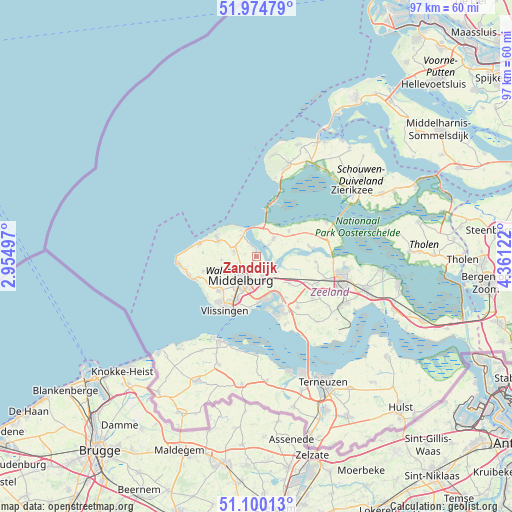
| Upper-left | 51.97479°, | 2.95497° |
| Center: | 51.53956°, | 3.6581° |
| Lower-right: | 51.10013°, | 4.36122° |
| Map W x H: | 97.3×97.3 km | = 60.5×60.5mi |
| max Lat: | 53.48025° ⇑77.7% North |
| Zanddijk: | 51.53956° |
| min Lat: | ⇓22.3% South 50.76917° |
| min Long | Zanddijk | max Long |
| 3.38611° | 3.6581° | 7.16528° |
| W 1.6%⇐ | ⇒98.4% E |
Elevation
Elevation of Zanddijk is 1 m = 3 ft, and this is 14 m = 46 ft below average elevation for this country.
| Max E: |
203 m = 666 ft | 83.9% |
| Avg. | 15 m = 49 ft | |
| Zanddijk | 1 m = 3 ft | |
Min E: |
-6 m = -20 ft | 16.1% |
See also: Netherlands elevation on elevation.city.
Geographical zone
Zanddijk is located in North temperate zone (between Tropic of Cancer and the Arctic Circle). Distance of this North polar circle is 1670.5 km =1038 mi to North.| Distance of | km | miles | from Zanddijk |
|---|---|---|---|
| North Pole | 4276.4 | 2657.2 | to North |
| Arctic Circle | 1670.5 | 1038 | to North |
| Tropic Cancer | 3124.7 | 1941.6 | to South |
| Equator | 5730.7 | 3560.9 | to South |


Nearby cities:
15 places around Zanddijk: (largest is in red/bold)
• Arnemuiden
4.4 km =2.7 mi,  164°
164°
• Brigdamme
4.5 km =2.8 mi,  234°
234°
• Dauwendaele
5.6 km =3.5 mi,  203°
203°
• Griffioen
5.7 km =3.5 mi, 228°
• Grijpskerke
6.7 km =4.2 mi,  264°
264°
• Kamperland
4.8 km =3 mi,  41°
41°
• Klarenbeek
4.6 km =2.9 mi,  224°
224°
• Middelburg
5.4 km =3.4 mi,  214°
214°
• Nieuw- en Sint Joosland
6.3 km =3.9 mi,  180°
180°
• Oostkapelle
8 km =5 mi,  292°
292°
• Serooskerke
4.5 km =2.8 mi,  282°
282°
• Sint Laurens
4.1 km =2.5 mi,  250°
250°
• Vrouwenpolder
5.1 km =3.2 mi,  324°
324°
• West-Souburg
9.6 km =6 mi, 208°
• Wissenkerke
8 km =5 mi,  50°
50°
Sources, notices
• [Note1] Compared only with cities in Netherlands existing in our database
• [Src1] Map data: © OpenStreetMap contributors (CC-BY-SA)
• [Src2] Other city data from geonames.org with taken over terms of usage.
• [Src3] Geographical zone / Annual Mean Temperature by Robert A. Rohde @ Wikipedia
