Rottum geodata
Rottum (Friesland) is a populated place; located in Netherlands in Europe/Amsterdam (GMT+2) time zone. With population of 660 people, there are 1666 cities with bigger population in this country. Compared to other cities in Netherlands, 83.6% of cities are located further ↓South; 63.9% of cities are located further ←West and 96.1% of cities have higher elevation than Rottum. Note1


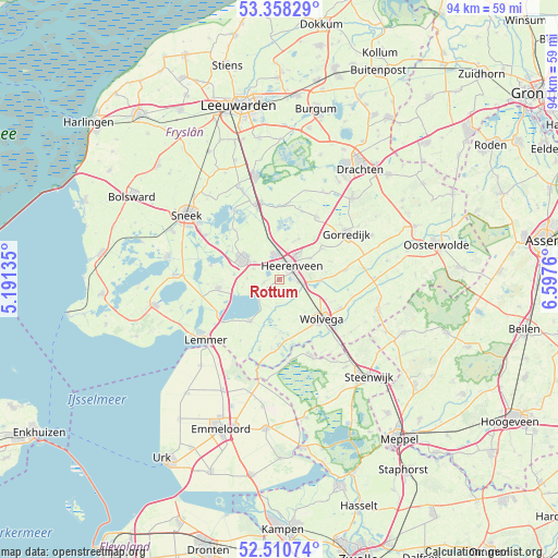
Rottum GPS coordinates[2]
52° 56' 11.724" North, 5° 53' 40.092" East
| Map corner | latitude | longitude |
|---|---|---|
| Upper-left | 53.35829°, | 5.19135° |
| Center: | 52.93659°, | 5.89447° |
| Lower-right: | 52.51074°, | 6.5976° |
| Map W x H: | 94.2×94.2 km | = 58.5×58.5mi |
| max Lat: | 53.48025° ⇑16.4% North |
| Rottum: | 52.93659° |
| min Lat: | ⇓83.6% South 50.76917° |
| min Long | Rottum | max Long |
| 3.38611° | 5.89447° | 7.16528° |
| W 63.9%⇐ | ⇒36.1% E |
Elevation
Elevation of Rottum is -1 m = -3 ft, and this is 16 m = 52 ft below average elevation for this country.
| Max E: |
203 m = 666 ft | 96.1% |
| Avg. | 15 m = 49 ft | |
| Rottum | -1 m = -3 ft | |
Min E: |
-6 m = -20 ft | 3.9% |
See also: Netherlands elevation on elevation.city.
Geographical zone
Rottum is located in North temperate zone (between Tropic of Cancer and the Arctic Circle). Distance of this North polar circle is 1515.2 km =941.5 mi to North.| Distance of | km | miles | from Rottum |
|---|---|---|---|
| North Pole | 4121.1 | 2560.7 | to North |
| Arctic Circle | 1515.2 | 941.5 | to North |
| Tropic Cancer | 3280.1 | 2038.2 | to South |
| Equator | 5886 | 3657.4 | to South |


Nearby cities:
15 places around Rottum: (largest is in red/bold)
• De Greiden
1.9 km =1.2 mi,  41°
41°
• De Knipe
6.2 km =3.9 mi,  55°
55°
• Echtenerbrug
8.7 km =5.4 mi,  214°
214°
• Haskerhorne
4.7 km =2.9 mi,  293°
293°
• Heerenveen
3 km =1.9 mi,  32°
32°
• Joure
6.9 km =4.3 mi,  297°
297°
• Katlijk
8 km =5 mi,  82°
82°
• Mildam
7.2 km =4.5 mi,  90°
90°
• Oranjewoud
3.9 km =2.4 mi,  74°
74°
• Oudehaske
2.8 km =1.7 mi,  325°
325°
• Oudeschoot
4.1 km =2.5 mi, 94°
• Rotsterhaule
3.4 km =2.1 mi,  236°
236°
• Scharsterbrug
7.8 km =4.8 mi,  276°
276°
• Sintjohannesga
2.6 km =1.6 mi,  257°
257°
• Tjalleberd
7.5 km =4.7 mi, 26°
Sources, notices
• [Note1] Compared only with cities in Netherlands existing in our database
• [Src1] Map data: © OpenStreetMap contributors (CC-BY-SA)
• [Src2] Other city data from geonames.org with taken over terms of usage.
• [Src3] Geographical zone / Annual Mean Temperature by Robert A. Rohde @ Wikipedia
