Steenwijkerwold geodata
Steenwijkerwold (Overijssel) is a populated place; located in Netherlands in Europe/Amsterdam (GMT+2) time zone. With population of 1,720 people, there are 1040 cities with bigger population in this country. Compared to other cities in Netherlands, 80.1% of cities are located further ↓South; 77.1% of cities are located further ←West and 64.6% of cities have lower elevation than Steenwijkerwold. Note1


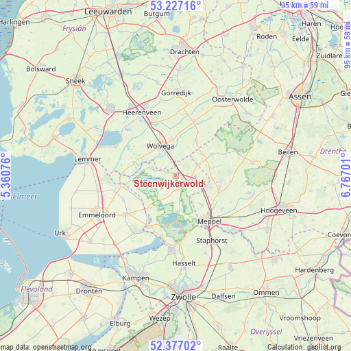
Steenwijkerwold GPS coordinates[2]
52° 48' 15.012" North, 6° 3' 50.004" East
| Map corner | latitude | longitude |
|---|---|---|
| Upper-left | 53.22716°, | 5.36076° |
| Center: | 52.80417°, | 6.06389° |
| Lower-right: | 52.37702°, | 6.76701° |
| Map W x H: | 94.5×94.5 km | = 58.7×58.7mi |
| max Lat: | 53.48025° ⇑19.9% North |
| Steenwijkerwold: | 52.80417° |
| min Lat: | ⇓80.1% South 50.76917° |
| min Long | Steenwijkerwold | max Long |
| 3.38611° | 6.06389° | 7.16528° |
| W 77.1%⇐ | ⇒22.9% E |
Elevation
Elevation of Steenwijkerwold is 12 m = 39 ft, and this is 3 m = 10 ft below average elevation for this country.
| Max E: |
203 m = 666 ft | 35.4% |
| Avg. | 15 m = 49 ft | |
| Steenwijkerwold | 12 m = 39 ft | |
Min E: |
-6 m = -20 ft | 64.6% |
See also: Netherlands elevation on elevation.city.
Geographical zone
Steenwijkerwold is located in North temperate zone (between Tropic of Cancer and the Arctic Circle). Distance of this North polar circle is 1529.9 km =950.6 mi to North.| Distance of | km | miles | from Steenwijkerwold |
|---|---|---|---|
| North Pole | 4135.8 | 2569.9 | to North |
| Arctic Circle | 1529.9 | 950.6 | to North |
| Tropic Cancer | 3265.4 | 2029 | to South |
| Equator | 5871.3 | 3648.3 | to South |


Nearby cities:
15 places around Steenwijkerwold: (largest is in red/bold)
• Blokzijl
11 km =6.8 mi,  218°
218°
• Darp
10 km =6.2 mi,  108°
108°
• De Blesse
4.6 km =2.9 mi,  340°
340°
• Giethoorn
7.2 km =4.5 mi,  171°
171°
• Noordwolde
10.8 km =6.7 mi,  28°
28°
• Oldeholtpade
9.9 km =6.2 mi,  353°
353°
• Oldemarkt
6.3 km =3.9 mi,  287°
287°
• Oostermeenthe
4.7 km =2.9 mi, 105°
• Steenwijk
4.3 km =2.7 mi,  115°
115°
• Steggerda
6 km =3.7 mi,  7°
7°
• Tuk
2.2 km =1.4 mi, 112°
• Wilhelminaoord
8.8 km =5.5 mi,  49°
49°
• Willemsoord
2.3 km =1.4 mi, 353°
• Wolvega
9.1 km =5.7 mi,  330°
330°
• Zuidveen
4.1 km =2.5 mi,  135°
135°
Sources, notices
• [Note1] Compared only with cities in Netherlands existing in our database
• [Src1] Map data: © OpenStreetMap contributors (CC-BY-SA)
• [Src2] Other city data from geonames.org with taken over terms of usage.
• [Src3] Geographical zone / Annual Mean Temperature by Robert A. Rohde @ Wikipedia
