Woldendorp geodata
Woldendorp (Groningen) is a populated place; located in Netherlands in Europe/Amsterdam (GMT+2) time zone. With population of 920 people, there are 1448 cities with bigger population in this country. Compared to other cities in Netherlands, 96.6% of cities are located further ↓South; 99.3% of cities are located further ←West and 96.1% of cities have higher elevation than Woldendorp. Note1


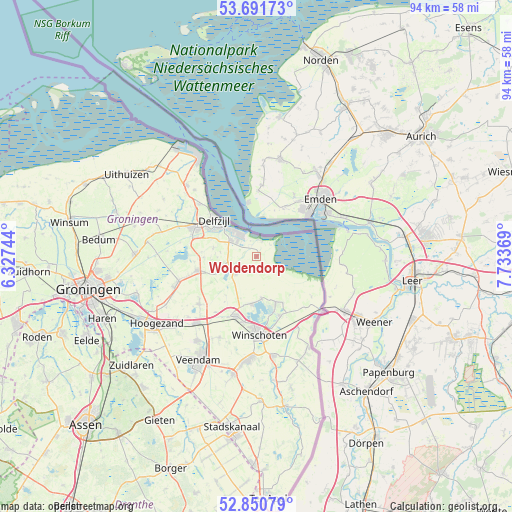
Woldendorp GPS coordinates[2]
53° 16' 23.988" North, 7° 1' 50.016" East
| Map corner | latitude | longitude |
|---|---|---|
| Upper-left | 53.69173°, | 6.32744° |
| Center: | 53.27333°, | 7.03056° |
| Lower-right: | 52.85079°, | 7.73369° |
| Map W x H: | 93.5×93.5 km | = 58.1×58.1mi |
| max Lat: | 53.48025° ⇑3.4% North |
| Woldendorp: | 53.27333° |
| min Lat: | ⇓96.6% South 50.76917° |
| min Long | Woldendorp | max Long |
| 3.38611° | 7.03056° | 7.16528° |
| W 99.3%⇐ | ⇒0.7% E |
Elevation
Elevation of Woldendorp is -1 m = -3 ft, and this is 16 m = 52 ft below average elevation for this country.
| Max E: |
203 m = 666 ft | 96.1% |
| Avg. | 15 m = 49 ft | |
| Woldendorp | -1 m = -3 ft | |
Min E: |
-6 m = -20 ft | 3.9% |
See also: Netherlands elevation on elevation.city.
Geographical zone
Woldendorp is located in North temperate zone (between Tropic of Cancer and the Arctic Circle). Distance of this North polar circle is 1477.7 km =918.2 mi to North.| Distance of | km | miles | from Woldendorp |
|---|---|---|---|
| North Pole | 4083.6 | 2537.4 | to North |
| Arctic Circle | 1477.7 | 918.2 | to North |
| Tropic Cancer | 3317.5 | 2061.4 | to South |
| Equator | 5923.4 | 3680.6 | to South |


Nearby cities:
15 places around Woldendorp: (largest is in red/bold)
• Appingedam
12.6 km =7.8 mi,  295°
295°
• Delfzijl
9.8 km =6.1 mi,  310°
310°
• Eexta
12.6 km =7.8 mi,  194°
194°
• Farmsum
8.8 km =5.5 mi, 307°
• Heiligerlee
13 km =8.1 mi, 186°
• Hellum
13.3 km =8.3 mi,  253°
253°
• Holwierde
14.1 km =8.8 mi, 312°
• Midwolda
8.8 km =5.5 mi, 187°
• Nieuwolda
4.9 km =3 mi,  228°
228°
• Noordbroek
13.6 km =8.5 mi, 230°
• Oostwold
7.9 km =4.9 mi,  172°
172°
• Scheemda
11.8 km =7.3 mi,  199°
199°
• Siddeburen
11.1 km =6.9 mi,  256°
256°
• Tuikwerd
9.9 km =6.2 mi, 299°
• Wagenborgen
6.8 km =4.2 mi, 253°
Sources, notices
• [Note1] Compared only with cities in Netherlands existing in our database
• [Src1] Map data: © OpenStreetMap contributors (CC-BY-SA)
• [Src2] Other city data from geonames.org with taken over terms of usage.
• [Src3] Geographical zone / Annual Mean Temperature by Robert A. Rohde @ Wikipedia
