Noordbroek geodata
Noordbroek (Groningen) is a populated place; located in Netherlands in Europe/Amsterdam (GMT+2) time zone. With population of 1,665 people, there are 1054 cities with bigger population in this country. Compared to other cities in Netherlands, 92.9% of cities are located further ↓South; 96.5% of cities are located further ←West and 74.9% of cities have higher elevation than Noordbroek. Note1


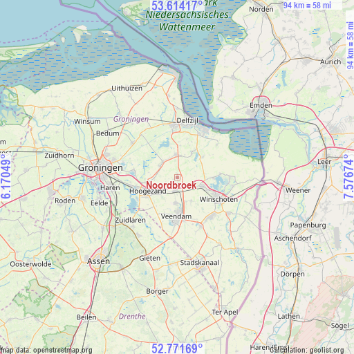
Noordbroek GPS coordinates[2]
53° 11' 42" North, 6° 52' 24.996" East
| Map corner | latitude | longitude |
|---|---|---|
| Upper-left | 53.61417°, | 6.17049° |
| Center: | 53.195°, | 6.87361° |
| Lower-right: | 52.77169°, | 7.57674° |
| Map W x H: | 93.7×93.7 km | = 58.2×58.2mi |
| max Lat: | 53.48025° ⇑7.1% North |
| Noordbroek: | 53.195° |
| min Lat: | ⇓92.9% South 50.76917° |
| min Long | Noordbroek | max Long |
| 3.38611° | 6.87361° | 7.16528° |
| W 96.5%⇐ | ⇒3.5% E |
Elevation
Elevation of Noordbroek is 2 m = 7 ft, and this is 13 m = 43 ft below average elevation for this country.
| Max E: |
203 m = 666 ft | 74.9% |
| Avg. | 15 m = 49 ft | |
| Noordbroek | 2 m = 7 ft | |
Min E: |
-6 m = -20 ft | 25.1% |
See also: Netherlands elevation on elevation.city.
Geographical zone
Noordbroek is located in North temperate zone (between Tropic of Cancer and the Arctic Circle). Distance of this North polar circle is 1486.4 km =923.6 mi to North.| Distance of | km | miles | from Noordbroek |
|---|---|---|---|
| North Pole | 4092.3 | 2542.8 | to North |
| Arctic Circle | 1486.4 | 923.6 | to North |
| Tropic Cancer | 3308.8 | 2056 | to South |
| Equator | 5914.7 | 3675.2 | to South |


Nearby cities:
15 places around Noordbroek: (largest is in red/bold)
• Eexta
8.1 km =5 mi,  115°
115°
• Froombosch
6.2 km =3.9 mi,  269°
269°
• Hellum
5.3 km =3.3 mi,  334°
334°
• Hoogezand
8.4 km =5.2 mi,  243°
243°
• Kolham
8.7 km =5.4 mi,  260°
260°
• Meeden
7.1 km =4.4 mi,  150°
150°
• Midwolda
9.3 km =5.8 mi,  90°
90°
• Nieuwolda
8.7 km =5.4 mi,  50°
50°
• Sappemeer
6.5 km =4 mi, 238°
• Scheemda
7 km =4.3 mi,  110°
110°
• Schildwolde
5.7 km =3.5 mi,  317°
317°
• Siddeburen
6.1 km =3.8 mi,  356°
356°
• Slochteren
5.4 km =3.4 mi,  302°
302°
• Wagenborgen
7.8 km =4.8 mi,  30°
30°
• Zuidbroek
3.6 km =2.2 mi,  193°
193°
Sources, notices
• [Note1] Compared only with cities in Netherlands existing in our database
• [Src1] Map data: © OpenStreetMap contributors (CC-BY-SA)
• [Src2] Other city data from geonames.org with taken over terms of usage.
• [Src3] Geographical zone / Annual Mean Temperature by Robert A. Rohde @ Wikipedia
