Scheemda geodata
Scheemda (Groningen) is a populated place; located in Netherlands in Europe/Amsterdam (GMT+2) time zone. With population of 2,395 people, there are 864 cities with bigger population in this country. Compared to other cities in Netherlands, 91.8% of cities are located further ↓South; 98.5% of cities are located further ←West and 74.9% of cities have higher elevation than Scheemda. Note1


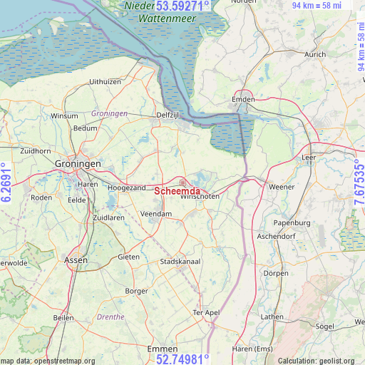
Scheemda GPS coordinates[2]
53° 10' 23.988" North, 6° 58' 19.992" East
| Map corner | latitude | longitude |
|---|---|---|
| Upper-left | 53.59271°, | 6.2691° |
| Center: | 53.17333°, | 6.97222° |
| Lower-right: | 52.74981°, | 7.67535° |
| Map W x H: | 93.7×93.7 km | = 58.2×58.2mi |
| max Lat: | 53.48025° ⇑8.2% North |
| Scheemda: | 53.17333° |
| min Lat: | ⇓91.8% South 50.76917° |
| min Long | Scheemda | max Long |
| 3.38611° | 6.97222° | 7.16528° |
| W 98.5%⇐ | ⇒1.5% E |
Elevation
Elevation of Scheemda is 2 m = 7 ft, and this is 13 m = 43 ft below average elevation for this country.
| Max E: |
203 m = 666 ft | 74.9% |
| Avg. | 15 m = 49 ft | |
| Scheemda | 2 m = 7 ft | |
Min E: |
-6 m = -20 ft | 25.1% |
See also: Netherlands elevation on elevation.city.
Geographical zone
Scheemda is located in North temperate zone (between Tropic of Cancer and the Arctic Circle). Distance of this North polar circle is 1488.9 km =925.2 mi to North.| Distance of | km | miles | from Scheemda |
|---|---|---|---|
| North Pole | 4094.7 | 2544.3 | to North |
| Arctic Circle | 1488.9 | 925.2 | to North |
| Tropic Cancer | 3306.4 | 2054.5 | to South |
| Equator | 5912.3 | 3673.7 | to South |


Nearby cities:
15 places around Scheemda: (largest is in red/bold)
• Blijham
10 km =6.2 mi,  135°
135°
• Eexta
1.3 km =0.8 mi, 144°
• Heiligerlee
3.1 km =1.9 mi,  126°
126°
• Meeden
4.8 km =3 mi,  219°
219°
• Midwolda
3.7 km =2.3 mi,  49°
49°
• Nieuwolda
7.9 km =4.9 mi,  1°
1°
• Noordbroek
7 km =4.3 mi,  290°
290°
• Ommelanderwijk
10.4 km =6.5 mi,  205°
205°
• Oostwold
5.9 km =3.7 mi,  56°
56°
• Oude Pekela
8.1 km =5 mi,  161°
161°
• Veendam
9.7 km =6 mi, 219°
• Wagenborgen
9.5 km =5.9 mi,  344°
344°
• Westerlee
3.2 km =2 mi, 161°
• Winschoten
5.3 km =3.3 mi, 127°
• Zuidbroek
7.5 km =4.7 mi,  261°
261°
Sources, notices
• [Note1] Compared only with cities in Netherlands existing in our database
• [Src1] Map data: © OpenStreetMap contributors (CC-BY-SA)
• [Src2] Other city data from geonames.org with taken over terms of usage.
• [Src3] Geographical zone / Annual Mean Temperature by Robert A. Rohde @ Wikipedia
