Wirdum geodata
Wirdum (Friesland) is a populated place; located in Netherlands in Europe/Amsterdam (GMT+2) time zone. With population of 1,050 people, there are 1363 cities with bigger population in this country. Compared to other cities in Netherlands, 90.6% of cities are located further ↓South; 58% of cities are located further ←West and 65.8% of cities have higher elevation than Wirdum. Note1


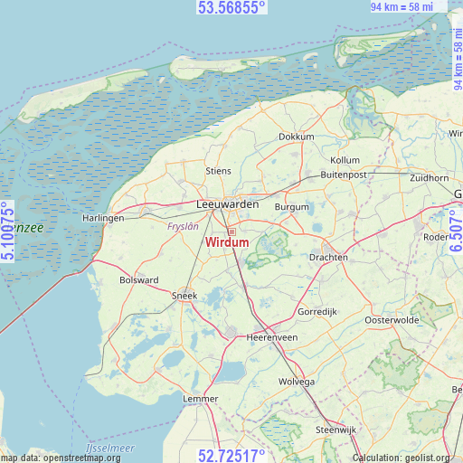
Wirdum GPS coordinates[2]
53° 8' 56.148" North, 5° 48' 13.932" East
| Map corner | latitude | longitude |
|---|---|---|
| Upper-left | 53.56855°, | 5.10075° |
| Center: | 53.14893°, | 5.80387° |
| Lower-right: | 52.72517°, | 6.507° |
| Map W x H: | 93.8×93.8 km | = 58.3×58.3mi |
| max Lat: | 53.48025° ⇑9.4% North |
| Wirdum: | 53.14893° |
| min Lat: | ⇓90.6% South 50.76917° |
| min Long | Wirdum | max Long |
| 3.38611° | 5.80387° | 7.16528° |
| W 58%⇐ | ⇒42% E |
Elevation
Elevation of Wirdum is 3 m = 10 ft, and this is 12 m = 39 ft below average elevation for this country.
| Max E: |
203 m = 666 ft | 65.8% |
| Avg. | 15 m = 49 ft | |
| Wirdum | 3 m = 10 ft | |
Min E: |
-6 m = -20 ft | 34.2% |
See also: Netherlands elevation on elevation.city.
Geographical zone
Wirdum is located in North temperate zone (between Tropic of Cancer and the Arctic Circle). Distance of this North polar circle is 1491.6 km =926.8 mi to North.| Distance of | km | miles | from Wirdum |
|---|---|---|---|
| North Pole | 4097.5 | 2546.1 | to North |
| Arctic Circle | 1491.6 | 926.8 | to North |
| Tropic Cancer | 3303.7 | 2052.8 | to South |
| Equator | 5909.6 | 3672.1 | to South |


Nearby cities:
15 places around Wirdum: (largest is in red/bold)
• Aldlân-Oost
4.7 km =2.9 mi,  20°
20°
• Goutum
3.2 km =2 mi,  359°
359°
• Grou
6.4 km =4 mi,  159°
159°
• Heechterp
6.9 km =4.3 mi,  10°
10°
• Hoek
6.2 km =3.9 mi, 358°
• Huizum
4.8 km =3 mi, 5°
• Leeuwarden
5.8 km =3.6 mi,  3°
3°
• Mantgum
6.1 km =3.8 mi,  248°
248°
• Raerd
6.4 km =4 mi,  207°
207°
• Reduzum
3.6 km =2.2 mi,  197°
197°
• Warga
2.7 km =1.7 mi,  84°
84°
• Warten
6.4 km =4 mi,  88°
88°
• Weidum
4.1 km =2.5 mi,  264°
264°
• Westeinde
7 km =4.3 mi,  340°
340°
• Zuiderburen
3.8 km =2.4 mi,  43°
43°
Sources, notices
• [Note1] Compared only with cities in Netherlands existing in our database
• [Src1] Map data: © OpenStreetMap contributors (CC-BY-SA)
• [Src2] Other city data from geonames.org with taken over terms of usage.
• [Src3] Geographical zone / Annual Mean Temperature by Robert A. Rohde @ Wikipedia
