Grou geodata
Grou (Friesland) is a seat of a second-order administrative division; located in Netherlands in Europe/Amsterdam (GMT+2) time zone. With population of 5,535 people, there are 438 cities with bigger population in this country. Compared to other cities in Netherlands, 88.7% of cities are located further ↓South; 60.2% of cities are located further ←West and 74.9% of cities have higher elevation than Grou. Note1


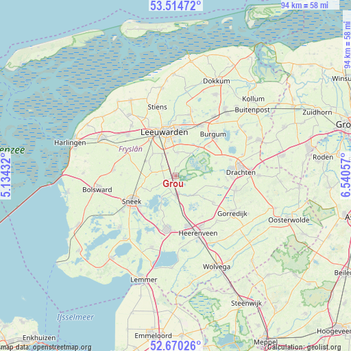
Grou GPS coordinates[2]
53° 5' 40.416" North, 5° 50' 14.82" East
| Map corner | latitude | longitude |
|---|---|---|
| Upper-left | 53.51472°, | 5.13432° |
| Center: | 53.09456°, | 5.83745° |
| Lower-right: | 52.67026°, | 6.54057° |
| Map W x H: | 93.9×93.9 km | = 58.3×58.3mi |
| max Lat: | 53.48025° ⇑11.3% North |
| Grou: | 53.09456° |
| min Lat: | ⇓88.7% South 50.76917° |
| min Long | Grou | max Long |
| 3.38611° | 5.83745° | 7.16528° |
| W 60.2%⇐ | ⇒39.8% E |
Elevation
Elevation of Grou is 2 m = 7 ft, and this is 13 m = 43 ft below average elevation for this country.
| Max E: |
203 m = 666 ft | 74.9% |
| Avg. | 15 m = 49 ft | |
| Grou | 2 m = 7 ft | |
Min E: |
-6 m = -20 ft | 25.1% |
See also: Netherlands elevation on elevation.city.
Geographical zone
Grou is located in North temperate zone (between Tropic of Cancer and the Arctic Circle). Distance of this North polar circle is 1497.6 km =930.6 mi to North.| Distance of | km | miles | from Grou |
|---|---|---|---|
| North Pole | 4103.5 | 2549.8 | to North |
| Arctic Circle | 1497.6 | 930.6 | to North |
| Tropic Cancer | 3297.6 | 2049 | to South |
| Equator | 5903.6 | 3668.3 | to South |


Nearby cities:
15 places around Grou: (largest is in red/bold)
• Akkrum
4.9 km =3 mi,  185°
185°
• Aldeboarn
6.5 km =4 mi,  139°
139°
• Aldlân-Oost
10.5 km =6.5 mi,  356°
356°
• Goutum
9.5 km =5.9 mi,  346°
346°
• Jirnsum
3.5 km =2.2 mi,  237°
237°
• Mantgum
8.8 km =5.5 mi,  295°
295°
• Nes
4.8 km =3 mi,  168°
168°
• Raerd
5.2 km =3.2 mi,  273°
273°
• Reduzum
4.2 km =2.6 mi,  307°
307°
• Terherne
7.7 km =4.8 mi,  207°
207°
• Warga
6.3 km =3.9 mi,  3°
3°
• Warten
7.4 km =4.6 mi,  34°
34°
• Weidum
8.5 km =5.3 mi, 312°
• Wirdum
6.4 km =4 mi,  339°
339°
• Zuiderburen
8.8 km =5.5 mi, 2°
Sources, notices
• [Note1] Compared only with cities in Netherlands existing in our database
• [Src1] Map data: © OpenStreetMap contributors (CC-BY-SA)
• [Src2] Other city data from geonames.org with taken over terms of usage.
• [Src3] Geographical zone / Annual Mean Temperature by Robert A. Rohde @ Wikipedia
