Raerd geodata
Raerd (Friesland) is a populated place; located in Netherlands in Europe/Amsterdam (GMT+2) time zone. With population of 630 people, there are 1686 cities with bigger population in this country. Compared to other cities in Netherlands, 88.8% of cities are located further ↓South; 55.1% of cities are located further ←West and 74.9% of cities have higher elevation than Raerd. Note1


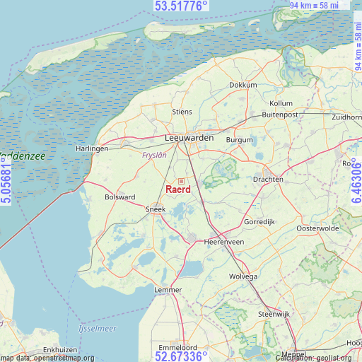
Raerd GPS coordinates[2]
53° 5' 51.468" North, 5° 45' 35.748" East
| Map corner | latitude | longitude |
|---|---|---|
| Upper-left | 53.51776°, | 5.05681° |
| Center: | 53.09763°, | 5.75993° |
| Lower-right: | 52.67336°, | 6.46306° |
| Map W x H: | 93.9×93.9 km | = 58.3×58.3mi |
| max Lat: | 53.48025° ⇑11.2% North |
| Raerd: | 53.09763° |
| min Lat: | ⇓88.8% South 50.76917° |
| min Long | Raerd | max Long |
| 3.38611° | 5.75993° | 7.16528° |
| W 55.1%⇐ | ⇒44.9% E |
Elevation
Elevation of Raerd is 2 m = 7 ft, and this is 13 m = 43 ft below average elevation for this country.
| Max E: |
203 m = 666 ft | 74.9% |
| Avg. | 15 m = 49 ft | |
| Raerd | 2 m = 7 ft | |
Min E: |
-6 m = -20 ft | 25.1% |
See also: Netherlands elevation on elevation.city.
Geographical zone
Raerd is located in North temperate zone (between Tropic of Cancer and the Arctic Circle). Distance of this North polar circle is 1497.3 km =930.4 mi to North.| Distance of | km | miles | from Raerd |
|---|---|---|---|
| North Pole | 4103.2 | 2549.6 | to North |
| Arctic Circle | 1497.3 | 930.4 | to North |
| Tropic Cancer | 3298 | 2049.3 | to South |
| Equator | 5903.9 | 3668.5 | to South |


Nearby cities:
15 places around Raerd: (largest is in red/bold)
• Akkrum
7.1 km =4.4 mi,  138°
138°
• De Domp
9.2 km =5.7 mi,  216°
216°
• Goutum
9.3 km =5.8 mi,  18°
18°
• Grou
5.2 km =3.2 mi,  93°
93°
• Jirnsum
3.1 km =1.9 mi, 135°
• Mantgum
4.4 km =2.7 mi,  321°
321°
• Nes
8 km =5 mi,  129°
129°
• Reduzum
2.9 km =1.8 mi,  39°
39°
• Scharnegoutum
6.8 km =4.2 mi,  232°
232°
• Sneek
9.9 km =6.2 mi, 223°
• Stadsfenne
8.4 km =5.2 mi, 220°
• Terherne
7.3 km =4.5 mi,  167°
167°
• Warga
8.2 km =5.1 mi, 43°
• Weidum
5.5 km =3.4 mi,  348°
348°
• Wirdum
6.4 km =4 mi,  27°
27°
Sources, notices
• [Note1] Compared only with cities in Netherlands existing in our database
• [Src1] Map data: © OpenStreetMap contributors (CC-BY-SA)
• [Src2] Other city data from geonames.org with taken over terms of usage.
• [Src3] Geographical zone / Annual Mean Temperature by Robert A. Rohde @ Wikipedia
