Wijdenes geodata
Wijdenes (North Holland) is a populated place; located in Netherlands in Europe/Amsterdam (GMT+2) time zone. With population of 1,005 people, there are 1395 cities with bigger population in this country. Compared to other cities in Netherlands, 74.3% of cities are located further ↓South; 67.8% of cities are located further →East and 74.9% of cities have higher elevation than Wijdenes. Note1


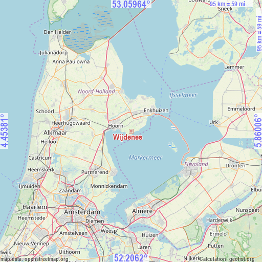
Wijdenes GPS coordinates[2]
52° 38' 6" North, 5° 9' 24.984" East
| Map corner | latitude | longitude |
|---|---|---|
| Upper-left | 53.05964°, | 4.45381° |
| Center: | 52.635°, | 5.15694° |
| Lower-right: | 52.2062°, | 5.86006° |
| Map W x H: | 94.9×94.9 km | = 59×59mi |
| max Lat: | 53.48025° ⇑25.7% North |
| Wijdenes: | 52.635° |
| min Lat: | ⇓74.3% South 50.76917° |
| min Long | Wijdenes | max Long |
| 3.38611° | 5.15694° | 7.16528° |
| W 32.2%⇐ | ⇒67.8% E |
Elevation
Elevation of Wijdenes is 2 m = 7 ft, and this is 13 m = 43 ft below average elevation for this country.
| Max E: |
203 m = 666 ft | 74.9% |
| Avg. | 15 m = 49 ft | |
| Wijdenes | 2 m = 7 ft | |
Min E: |
-6 m = -20 ft | 25.1% |
See also: Netherlands elevation on elevation.city.
Geographical zone
Wijdenes is located in North temperate zone (between Tropic of Cancer and the Arctic Circle). Distance of this North polar circle is 1548.7 km =962.3 mi to North.| Distance of | km | miles | from Wijdenes |
|---|---|---|---|
| North Pole | 4154.6 | 2581.5 | to North |
| Arctic Circle | 1548.7 | 962.3 | to North |
| Tropic Cancer | 3246.5 | 2017.3 | to South |
| Equator | 5852.5 | 3636.6 | to South |


Nearby cities:
15 places around Wijdenes: (largest is in red/bold)
• Bangert
11.3 km =7 mi,  7°
7°
• Berkhout
10.5 km =6.5 mi,  273°
273°
• Broekerhaven
8.8 km =5.5 mi,  47°
47°
• Enkhuizen
11.8 km =7.3 mi, 50°
• Hauwert
9 km =5.6 mi,  334°
334°
• Hem
3.4 km =2.1 mi,  31°
31°
• Hoorn
6.6 km =4.1 mi,  277°
277°
• Lutjebroek
7.6 km =4.7 mi,  24°
24°
• Midwoud
10.6 km =6.6 mi, 328°
• Oosterblokker
4.6 km =2.9 mi, 325°
• Oostwoud
11.2 km =7 mi, 334°
• Schellinkhout
2.4 km =1.5 mi, 270°
• Westwoud
5.8 km =3.6 mi,  344°
344°
• Zwaagdijk-Oost
8.1 km =5 mi,  352°
352°
• Zwaagdijk-West
8.2 km =5.1 mi,  302°
302°
Sources, notices
• [Note1] Compared only with cities in Netherlands existing in our database
• [Src1] Map data: © OpenStreetMap contributors (CC-BY-SA)
• [Src2] Other city data from geonames.org with taken over terms of usage.
• [Src3] Geographical zone / Annual Mean Temperature by Robert A. Rohde @ Wikipedia
