Berkhout geodata
Berkhout (North Holland) is a populated place; located in Netherlands in Europe/Amsterdam (GMT+2) time zone. With population of 1,905 people, there are 992 cities with bigger population in this country. Compared to other cities in Netherlands, 74.5% of cities are located further ↓South; 73.5% of cities are located further →East and 98.2% of cities have higher elevation than Berkhout. Note1


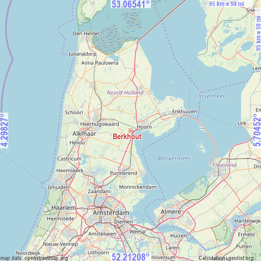
Berkhout GPS coordinates[2]
52° 38' 26.988" North, 5° 0' 5.004" East
| Map corner | latitude | longitude |
|---|---|---|
| Upper-left | 53.06541°, | 4.29827° |
| Center: | 52.64083°, | 5.00139° |
| Lower-right: | 52.21208°, | 5.70452° |
| Map W x H: | 94.9×94.9 km | = 59×59mi |
| max Lat: | 53.48025° ⇑25.5% North |
| Berkhout: | 52.64083° |
| min Lat: | ⇓74.5% South 50.76917° |
| min Long | Berkhout | max Long |
| 3.38611° | 5.00139° | 7.16528° |
| W 26.5%⇐ | ⇒73.5% E |
Elevation
Elevation of Berkhout is -2 m = -7 ft, and this is 17 m = 56 ft below average elevation for this country.
| Max E: |
203 m = 666 ft | 98.2% |
| Avg. | 15 m = 49 ft | |
| Berkhout | -2 m = -7 ft | |
Min E: |
-6 m = -20 ft | 1.8% |
See also: Netherlands elevation on elevation.city.
Geographical zone
Berkhout is located in North temperate zone (between Tropic of Cancer and the Arctic Circle). Distance of this North polar circle is 1548.1 km =961.9 mi to North.| Distance of | km | miles | from Berkhout |
|---|---|---|---|
| North Pole | 4154 | 2581.2 | to North |
| Arctic Circle | 1548.1 | 961.9 | to North |
| Tropic Cancer | 3247.2 | 2017.7 | to South |
| Equator | 5853.1 | 3636.9 | to South |


Nearby cities:
15 places around Berkhout: (largest is in red/bold)
• Avenhorn
4.3 km =2.7 mi,  232°
232°
• Beets
6.1 km =3.8 mi,  195°
195°
• De Goorn
4 km =2.5 mi,  245°
245°
• Hensbroek
8.1 km =5 mi,  283°
283°
• Hoogwoud
9.3 km =5.8 mi,  333°
333°
• Hoorn
3.9 km =2.4 mi,  87°
87°
• Obdam
7.5 km =4.7 mi,  301°
301°
• Oosterblokker
8.5 km =5.3 mi,  68°
68°
• Oosthuizen
7.6 km =4.7 mi,  182°
182°
• Opmeer
8.3 km =5.2 mi, 332°
• Schellinkhout
8.1 km =5 mi, 94°
• Schermerhorn
8.6 km =5.3 mi,  239°
239°
• Spierdijk
4.1 km =2.5 mi,  285°
285°
• Warder
8.6 km =5.3 mi,  168°
168°
• Zwaagdijk-West
5.2 km =3.2 mi,  43°
43°
Sources, notices
• [Note1] Compared only with cities in Netherlands existing in our database
• [Src1] Map data: © OpenStreetMap contributors (CC-BY-SA)
• [Src2] Other city data from geonames.org with taken over terms of usage.
• [Src3] Geographical zone / Annual Mean Temperature by Robert A. Rohde @ Wikipedia
