Westerlee geodata
Westerlee (Groningen) is a populated place; located in Netherlands in Europe/Amsterdam (GMT+2) time zone. With population of 1,295 people, there are 1242 cities with bigger population in this country. Compared to other cities in Netherlands, 90.4% of cities are located further ↓South; 98.8% of cities are located further ←West and 91.3% of cities have higher elevation than Westerlee. Note1


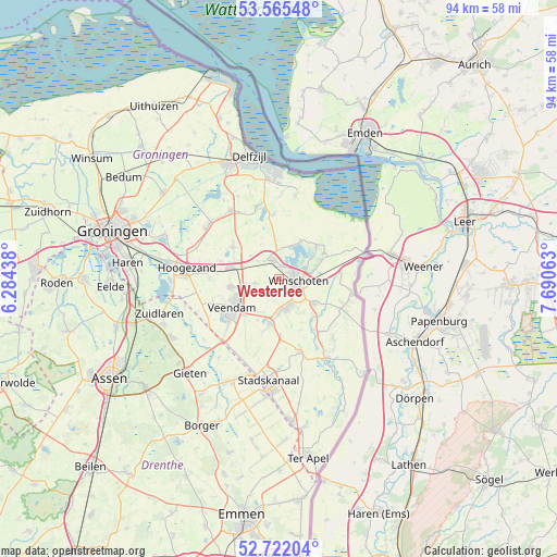
Westerlee GPS coordinates[2]
53° 8' 44.988" North, 6° 59' 15" East
| Map corner | latitude | longitude |
|---|---|---|
| Upper-left | 53.56548°, | 6.28438° |
| Center: | 53.14583°, | 6.9875° |
| Lower-right: | 52.72204°, | 7.69063° |
| Map W x H: | 93.8×93.8 km | = 58.3×58.3mi |
| max Lat: | 53.48025° ⇑9.6% North |
| Westerlee: | 53.14583° |
| min Lat: | ⇓90.4% South 50.76917° |
| min Long | Westerlee | max Long |
| 3.38611° | 6.9875° | 7.16528° |
| W 98.8%⇐ | ⇒1.2% E |
Elevation
Elevation of Westerlee is 0 m = 0 ft, and this is 15 m = 49 ft below average elevation for this country.
| Max E: |
203 m = 666 ft | 91.3% |
| Avg. | 15 m = 49 ft | |
| Westerlee | 0 m = 0 ft | |
Min E: |
-6 m = -20 ft | 8.7% |
See also: Netherlands elevation on elevation.city.
Geographical zone
Westerlee is located in North temperate zone (between Tropic of Cancer and the Arctic Circle). Distance of this North polar circle is 1491.9 km =927 mi to North.| Distance of | km | miles | from Westerlee |
|---|---|---|---|
| North Pole | 4097.8 | 2546.3 | to North |
| Arctic Circle | 1491.9 | 927 | to North |
| Tropic Cancer | 3303.3 | 2052.6 | to South |
| Equator | 5909.3 | 3671.9 | to South |


Nearby cities:
15 places around Westerlee: (largest is in red/bold)
• Blijham
7.2 km =4.5 mi,  124°
124°
• Eexta
2 km =1.2 mi,  352°
352°
• Heiligerlee
1.9 km =1.2 mi,  50°
50°
• Meeden
4.1 km =2.5 mi,  260°
260°
• Midwolda
5.7 km =3.5 mi,  17°
17°
• Nieuwe Pekela
7.6 km =4.7 mi,  191°
191°
• Noordbroek
9.4 km =5.8 mi,  305°
305°
• Ommelanderwijk
8.3 km =5.2 mi,  220°
220°
• Oostwold
7.4 km =4.6 mi,  31°
31°
• Oude Pekela
4.9 km =3 mi,  162°
162°
• Scheemda
3.2 km =2 mi,  341°
341°
• Veendam
8.4 km =5.2 mi,  238°
238°
• Wedde
10.5 km =6.5 mi,  144°
144°
• Winschoten
3.2 km =2 mi,  93°
93°
• Zuidbroek
8.6 km =5.3 mi,  283°
283°
Sources, notices
• [Note1] Compared only with cities in Netherlands existing in our database
• [Src1] Map data: © OpenStreetMap contributors (CC-BY-SA)
• [Src2] Other city data from geonames.org with taken over terms of usage.
• [Src3] Geographical zone / Annual Mean Temperature by Robert A. Rohde @ Wikipedia
