Wassenaar geodata
Wassenaar (South Holland) is a populated place; located in Netherlands in Europe/Amsterdam (GMT+2) time zone. With population of 25,353 people, there are 132 cities with bigger population in this country. Compared to other cities in Netherlands, 56.9% of cities are located further ↓South; 91.9% of cities are located further →East and 74.9% of cities have higher elevation than Wassenaar. Note1


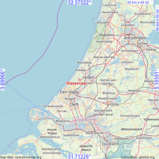
Wassenaar GPS coordinates[2]
52° 8' 44.988" North, 4° 24' 10.008" East
| Map corner | latitude | longitude |
|---|---|---|
| Upper-left | 52.57522°, | 3.69966° |
| Center: | 52.14583°, | 4.40278° |
| Lower-right: | 51.71226°, | 5.10591° |
| Map W x H: | 96×95.9 km | = 59.7×59.6mi |
| max Lat: | 53.48025° ⇑43.1% North |
| Wassenaar: | 52.14583° |
| min Lat: | ⇓56.9% South 50.76917° |
| min Long | Wassenaar | max Long |
| 3.38611° | 4.40278° | 7.16528° |
| W 8.1%⇐ | ⇒91.9% E |
Elevation
Elevation of Wassenaar is 2 m = 7 ft, and this is 13 m = 43 ft below average elevation for this country.
| Max E: |
203 m = 666 ft | 74.9% |
| Avg. | 15 m = 49 ft | |
| Wassenaar | 2 m = 7 ft | |
Min E: |
-6 m = -20 ft | 25.1% |
See also: Netherlands elevation on elevation.city.
Geographical zone
Wassenaar is located in North temperate zone (between Tropic of Cancer and the Arctic Circle). Distance of this North polar circle is 1603.1 km =996.1 mi to North.| Distance of | km | miles | from Wassenaar |
|---|---|---|---|
| North Pole | 4209 | 2615.4 | to North |
| Arctic Circle | 1603.1 | 996.1 | to North |
| Tropic Cancer | 3192.2 | 1983.5 | to South |
| Equator | 5798.1 | 3602.8 | to South |


Nearby cities:
15 places around Wassenaar: (largest is in red/bold)
• Adegeest
3.6 km =2.2 mi,  107°
107°
• De Kieviet
3.9 km =2.4 mi,  230°
230°
• Hoge Mors
4.1 km =2.5 mi,  73°
73°
• Katwijk aan Zee
6.4 km =4 mi,  357°
357°
• Katwijk aan den Rijn
5.5 km =3.4 mi,  13°
13°
• Kerkehout
4.3 km =2.7 mi,  201°
201°
• Leiden
6.3 km =3.9 mi,  77°
77°
• Noord-Hofland
3.9 km =2.4 mi,  98°
98°
• Oegstgeest
5.9 km =3.7 mi,  50°
50°
• Oostdorp
0.8 km =0.5 mi,  304°
304°
• Rijnsburg
5.6 km =3.5 mi,  28°
28°
• Valkenburg
4.3 km =2.7 mi, 27°
• Vlietwijk
4.4 km =2.7 mi,  122°
122°
• Voorschoten
3.7 km =2.3 mi, 123°
• Zoeterwoude-Dorp
7 km =4.3 mi, 114°
Sources, notices
• [Note1] Compared only with cities in Netherlands existing in our database
• [Src1] Map data: © OpenStreetMap contributors (CC-BY-SA)
• [Src2] Other city data from geonames.org with taken over terms of usage.
• [Src3] Geographical zone / Annual Mean Temperature by Robert A. Rohde @ Wikipedia
