Kerkehout geodata
Kerkehout (South Holland) is a populated place; located in Netherlands in Europe/Amsterdam (GMT+2) time zone. With population of 1,045 people, there are 1367 cities with bigger population in this country. Compared to other cities in Netherlands, 55.1% of cities are located further ↓South; 92.3% of cities are located further →East and 91.3% of cities have higher elevation than Kerkehout. Note1


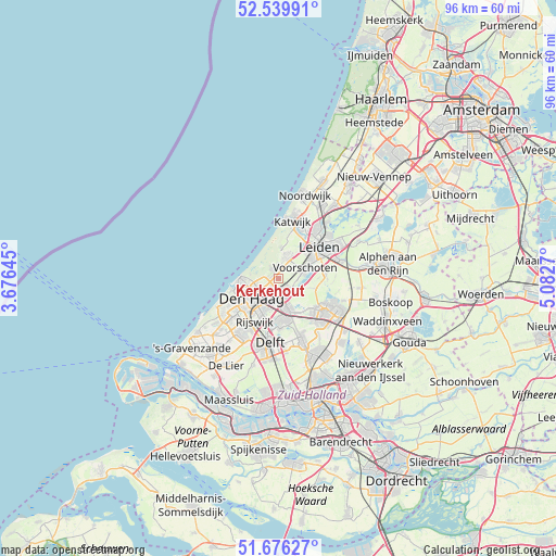
Kerkehout GPS coordinates[2]
52° 6' 36.648" North, 4° 22' 46.452" East
| Map corner | latitude | longitude |
|---|---|---|
| Upper-left | 52.53991°, | 3.67645° |
| Center: | 52.11018°, | 4.37957° |
| Lower-right: | 51.67627°, | 5.0827° |
| Map W x H: | 96×96 km | = 59.7×59.7mi |
| max Lat: | 53.48025° ⇑44.9% North |
| Kerkehout: | 52.11018° |
| min Lat: | ⇓55.1% South 50.76917° |
| min Long | Kerkehout | max Long |
| 3.38611° | 4.37957° | 7.16528° |
| W 7.7%⇐ | ⇒92.3% E |
Elevation
Elevation of Kerkehout is 0 m = 0 ft, and this is 15 m = 49 ft below average elevation for this country.
| Max E: |
203 m = 666 ft | 91.3% |
| Avg. | 15 m = 49 ft | |
| Kerkehout | 0 m = 0 ft | |
Min E: |
-6 m = -20 ft | 8.7% |
See also: Netherlands elevation on elevation.city.
Geographical zone
Kerkehout is located in North temperate zone (between Tropic of Cancer and the Arctic Circle). Distance of this North polar circle is 1607.1 km =998.6 mi to North.| Distance of | km | miles | from Kerkehout |
|---|---|---|---|
| North Pole | 4213 | 2617.8 | to North |
| Arctic Circle | 1607.1 | 998.6 | to North |
| Tropic Cancer | 3188.2 | 1981.1 | to South |
| Equator | 5794.1 | 3600.3 | to South |


Nearby cities:
15 places around Kerkehout: (largest is in red/bold)
• Adegeest
5.8 km =3.6 mi,  59°
59°
• De Kieviet
2.1 km =1.3 mi,  315°
315°
• Duinzigt
3.8 km =2.4 mi,  260°
260°
• Essesteijn
2.8 km =1.7 mi,  189°
189°
• Hoge Mors
7.5 km =4.7 mi,  47°
47°
• Noord-Hofland
6.4 km =4 mi, 57°
• Oostdorp
4.5 km =2.8 mi,  11°
11°
• Scheveningen
7.1 km =4.4 mi,  265°
265°
• Statenkwartier
7.3 km =4.5 mi, 255°
• The Hague
6.7 km =4.2 mi,  236°
236°
• Vlietwijk
5.5 km =3.4 mi,  73°
73°
• Voorburg
4.2 km =2.6 mi,  198°
198°
• Voorschoten
5.1 km =3.2 mi, 67°
• Wassenaar
4.3 km =2.7 mi,  21°
21°
• Ypenburg
7.7 km =4.8 mi,  184°
184°
Sources, notices
• [Note1] Compared only with cities in Netherlands existing in our database
• [Src1] Map data: © OpenStreetMap contributors (CC-BY-SA)
• [Src2] Other city data from geonames.org with taken over terms of usage.
• [Src3] Geographical zone / Annual Mean Temperature by Robert A. Rohde @ Wikipedia
