Zoeterwoude-Dorp geodata
Zoeterwoude-Dorp (South Holland) is a populated place; located in Netherlands in Europe/Amsterdam (GMT+2) time zone. With population of 4,230 people, there are 566 cities with bigger population in this country. Compared to other cities in Netherlands, 55.5% of cities are located further ↓South; 89.1% of cities are located further →East and 91.3% of cities have higher elevation than Zoeterwoude-Dorp. Note1


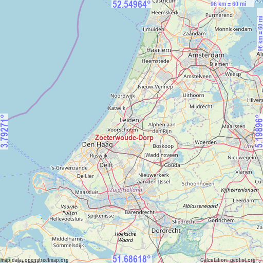
Zoeterwoude-Dorp GPS coordinates[2]
52° 7' 12" North, 4° 29' 44.988" East
| Map corner | latitude | longitude |
|---|---|---|
| Upper-left | 52.54964°, | 3.79271° |
| Center: | 52.12°, | 4.49583° |
| Lower-right: | 51.68618°, | 5.19896° |
| Map W x H: | 96×96 km | = 59.7×59.7mi |
| max Lat: | 53.48025° ⇑44.5% North |
| Zoeterwoude-Dorp: | 52.12° |
| min Lat: | ⇓55.5% South 50.76917° |
| min Long | Zoeterwoude-Dor | max Long |
| 3.38611° | 4.49583° | 7.16528° |
| W 10.9%⇐ | ⇒89.1% E |
Elevation
Elevation of Zoeterwoude-Dorp is 0 m = 0 ft, and this is 15 m = 49 ft below average elevation for this country.
| Max E: |
203 m = 666 ft | 91.3% |
| Avg. | 15 m = 49 ft | |
| Zoeterwoude-Dorp | 0 m = 0 ft | |
Min E: |
-6 m = -20 ft | 8.7% |
See also: Netherlands elevation on elevation.city.
Geographical zone
Zoeterwoude-Dorp is located in North temperate zone (between Tropic of Cancer and the Arctic Circle). Distance of this North polar circle is 1606 km =997.9 mi to North.| Distance of | km | miles | from Zoeterwoude-Dorp |
|---|---|---|---|
| North Pole | 4211.9 | 2617.2 | to North |
| Arctic Circle | 1606 | 997.9 | to North |
| Tropic Cancer | 3189.3 | 1981.7 | to South |
| Equator | 5795.2 | 3601 | to South |


Nearby cities:
15 places around Zoeterwoude-Dorp: (largest is in red/bold)
• Adegeest
3.5 km =2.2 mi,  301°
301°
• Benthuizen
5.8 km =3.6 mi,  144°
144°
• Binnenhof
5.6 km =3.5 mi,  29°
29°
• Hoge Mors
4.7 km =2.9 mi,  328°
328°
• Leiden
4.3 km =2.7 mi,  357°
357°
• Leiderdorp
4.8 km =3 mi, 28°
• Merenwijk
6.4 km =4 mi,  8°
8°
• Noord-Hofland
3.4 km =2.1 mi,  312°
312°
• Oegstgeest
6.9 km =4.3 mi,  344°
344°
• Palenstein
7.2 km =4.5 mi,  172°
172°
• Vlietwijk
2.7 km =1.7 mi,  280°
280°
• Voorschoten
3.3 km =2.1 mi, 284°
• Wassenaar
7 km =4.3 mi,  294°
294°
• Zoetermeer
7 km =4.3 mi,  181°
181°
• Zuidbuurt
1.4 km =0.9 mi,  156°
156°
Sources, notices
• [Note1] Compared only with cities in Netherlands existing in our database
• [Src1] Map data: © OpenStreetMap contributors (CC-BY-SA)
• [Src2] Other city data from geonames.org with taken over terms of usage.
• [Src3] Geographical zone / Annual Mean Temperature by Robert A. Rohde @ Wikipedia
