Vaassen geodata
Vaassen (Gelderland) is a populated place; located in Netherlands in Europe/Amsterdam (GMT+2) time zone. With population of 12,719 people, there are 241 cities with bigger population in this country. Compared to other cities in Netherlands, 65.8% of cities are located further ↓South; 69.5% of cities are located further ←West and 70.6% of cities have lower elevation than Vaassen. Note1


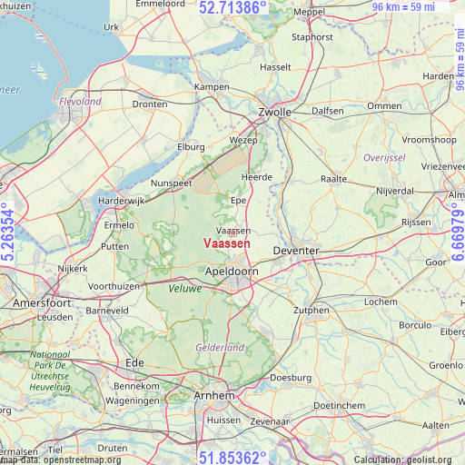
Vaassen GPS coordinates[2]
52° 17' 8.988" North, 5° 58' 0.012" East
| Map corner | latitude | longitude |
|---|---|---|
| Upper-left | 52.71386°, | 5.26354° |
| Center: | 52.28583°, | 5.96667° |
| Lower-right: | 51.85362°, | 6.66979° |
| Map W x H: | 95.6×95.6 km | = 59.4×59.4mi |
| max Lat: | 53.48025° ⇑34.2% North |
| Vaassen: | 52.28583° |
| min Lat: | ⇓65.8% South 50.76917° |
| min Long | Vaassen | max Long |
| 3.38611° | 5.96667° | 7.16528° |
| W 69.5%⇐ | ⇒30.5% E |
Elevation
Elevation of Vaassen is 15 m = 49 ft, and this is 0 m = 0 ft above average elevation for this country.
| Max E: |
203 m = 666 ft | 29.4% |
| Vaassen | 15 m 49 ft | |
| Avg. | 15 m = 49 ft | |
Min E: |
-6 m = -20 ft | 70.6% |
See also: Netherlands elevation on elevation.city.
Geographical zone
Vaassen is located in North temperate zone (between Tropic of Cancer and the Arctic Circle). Distance of this North polar circle is 1587.5 km =986.4 mi to North.| Distance of | km | miles | from Vaassen |
|---|---|---|---|
| North Pole | 4193.4 | 2605.7 | to North |
| Arctic Circle | 1587.5 | 986.4 | to North |
| Tropic Cancer | 3207.7 | 1993.2 | to South |
| Equator | 5813.6 | 3612.4 | to South |


Nearby cities:
15 places around Vaassen: (largest is in red/bold)
• Anklaar
6.2 km =3.9 mi,  168°
168°
• Beemte-Broekland
3.7 km =2.3 mi,  154°
154°
• Berg en Bos
7.7 km =4.8 mi,  197°
197°
• De Mheen
7.6 km =4.7 mi, 167°
• Emst
3.4 km =2.1 mi,  8°
8°
• Epe
6.9 km =4.3 mi, 9°
• Het Loo
5.9 km =3.7 mi,  189°
189°
• Hommelbrink
5.2 km =3.2 mi,  182°
182°
• Kerschoten
5.8 km =3.6 mi, 180°
• Sluisoord
7.1 km =4.4 mi, 171°
• Spainkbos
7.2 km =4.5 mi, 190°
• Sprengenbos
7.6 km =4.7 mi, 192°
• Sprengenweg-Noord
7.6 km =4.7 mi, 188°
• Sprenkelaar
7.1 km =4.4 mi,  161°
161°
• Zevenhuizen
7.6 km =4.7 mi, 173°
Sources, notices
• [Note1] Compared only with cities in Netherlands existing in our database
• [Src1] Map data: © OpenStreetMap contributors (CC-BY-SA)
• [Src2] Other city data from geonames.org with taken over terms of usage.
• [Src3] Geographical zone / Annual Mean Temperature by Robert A. Rohde @ Wikipedia
