Emst geodata
Emst (Gelderland) is a populated place; located in Netherlands in Europe/Amsterdam (GMT+2) time zone. With population of 1,310 people, there are 1233 cities with bigger population in this country. Compared to other cities in Netherlands, 66.9% of cities are located further ↓South; 70.3% of cities are located further ←West and 69% of cities have lower elevation than Emst. Note1


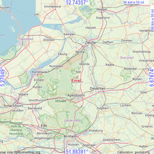
Emst GPS coordinates[2]
52° 18' 56.988" North, 5° 58' 24.996" East
| Map corner | latitude | longitude |
|---|---|---|
| Upper-left | 52.74357°, | 5.27049° |
| Center: | 52.31583°, | 5.97361° |
| Lower-right: | 51.88391°, | 6.67674° |
| Map W x H: | 95.6×95.6 km | = 59.4×59.4mi |
| max Lat: | 53.48025° ⇑33.1% North |
| Emst: | 52.31583° |
| min Lat: | ⇓66.9% South 50.76917° |
| min Long | Emst | max Long |
| 3.38611° | 5.97361° | 7.16528° |
| W 70.3%⇐ | ⇒29.7% E |
Elevation
Elevation of Emst is 14 m = 46 ft, and this is 1 m = 3 ft below average elevation for this country.
| Max E: |
203 m = 666 ft | 31% |
| Avg. | 15 m = 49 ft | |
| Emst | 14 m = 46 ft | |
Min E: |
-6 m = -20 ft | 69% |
See also: Netherlands elevation on elevation.city.
Geographical zone
Emst is located in North temperate zone (between Tropic of Cancer and the Arctic Circle). Distance of this North polar circle is 1584.2 km =984.4 mi to North.| Distance of | km | miles | from Emst |
|---|---|---|---|
| North Pole | 4190.1 | 2603.6 | to North |
| Arctic Circle | 1584.2 | 984.4 | to North |
| Tropic Cancer | 3211.1 | 1995.3 | to South |
| Equator | 5817 | 3614.5 | to South |


Nearby cities:
15 places around Emst: (largest is in red/bold)
• Anklaar
9.5 km =5.9 mi,  175°
175°
• Beemte-Broekland
6.7 km =4.2 mi,  170°
170°
• Boskamp
10.6 km =6.6 mi,  80°
80°
• Epe
3.6 km =2.2 mi,  10°
10°
• Heerde
9.1 km =5.7 mi,  29°
29°
• Het Loo
9.2 km =5.7 mi,  188°
188°
• Hommelbrink
8.6 km =5.3 mi, 184°
• Kerschoten
9.2 km =5.7 mi, 182°
• Oene
6 km =3.7 mi,  58°
58°
• Olst
9.6 km =6 mi, 75°
• Sluisoord
10.3 km =6.4 mi, 177°
• Sprenkelaar
10.2 km =6.3 mi, 170°
• Terwolde
9.3 km =5.8 mi,  112°
112°
• Vaassen
3.4 km =2.1 mi, 188°
• Welsum
8.3 km =5.2 mi,  74°
74°
Sources, notices
• [Note1] Compared only with cities in Netherlands existing in our database
• [Src1] Map data: © OpenStreetMap contributors (CC-BY-SA)
• [Src2] Other city data from geonames.org with taken over terms of usage.
• [Src3] Geographical zone / Annual Mean Temperature by Robert A. Rohde @ Wikipedia
