Tolkamer geodata
Tolkamer (Gelderland) is a populated place; located in Netherlands in Europe/Amsterdam (GMT+2) time zone. With population of 2,430 people, there are 855 cities with bigger population in this country. Compared to other cities in Netherlands, 61% of cities are located further ↑North; 79.6% of cities are located further ←West and 69% of cities have lower elevation than Tolkamer. Note1


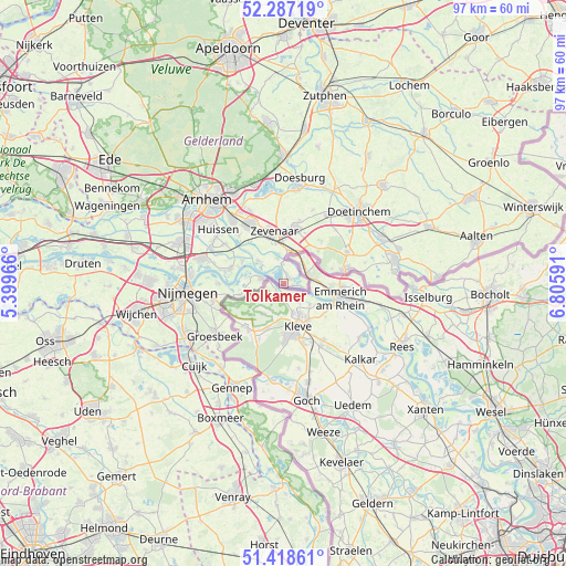
Tolkamer GPS coordinates[2]
51° 51' 18" North, 6° 6' 10.008" East
| Map corner | latitude | longitude |
|---|---|---|
| Upper-left | 52.28719°, | 5.39966° |
| Center: | 51.855°, | 6.10278° |
| Lower-right: | 51.41861°, | 6.80591° |
| Map W x H: | 96.6×96.6 km | = 60×60mi |
| max Lat: | 53.48025° ⇑61% North |
| Tolkamer: | 51.855° |
| min Lat: | ⇓39% South 50.76917° |
| min Long | Tolkamer | max Long |
| 3.38611° | 6.10278° | 7.16528° |
| W 79.6%⇐ | ⇒20.4% E |
Elevation
Elevation of Tolkamer is 14 m = 46 ft, and this is 1 m = 3 ft below average elevation for this country.
| Max E: |
203 m = 666 ft | 31% |
| Avg. | 15 m = 49 ft | |
| Tolkamer | 14 m = 46 ft | |
Min E: |
-6 m = -20 ft | 69% |
See also: Netherlands elevation on elevation.city.
Geographical zone
Tolkamer is located in North temperate zone (between Tropic of Cancer and the Arctic Circle). Distance of this North polar circle is 1635.4 km =1016.2 mi to North.| Distance of | km | miles | from Tolkamer |
|---|---|---|---|
| North Pole | 4241.3 | 2635.4 | to North |
| Arctic Circle | 1635.4 | 1016.2 | to North |
| Tropic Cancer | 3159.8 | 1963.4 | to South |
| Equator | 5765.7 | 3582.6 | to South |


Nearby cities:
15 places around Tolkamer: (largest is in red/bold)
• Aerdt
4.5 km =2.8 mi,  344°
344°
• Babberich
5.9 km =3.7 mi,  5°
5°
• Beek gem Montferland
8.2 km =5.1 mi,  45°
45°
• Doornenburg
8.1 km =5 mi,  298°
298°
• Gendt
9.4 km =5.8 mi,  285°
285°
• Herwen
3.3 km =2.1 mi,  356°
356°
• Leuth
7.8 km =4.8 mi,  257°
257°
• Lobith
1.3 km =0.8 mi, 51°
• Nieuw-Dijk
9.4 km =5.8 mi,  22°
22°
• Ooy
7.8 km =4.8 mi, 336°
• Pannerden
5.9 km =3.7 mi,  312°
312°
• Spijk
3.6 km =2.2 mi,  100°
100°
• Stokkum
8.5 km =5.3 mi,  72°
72°
• Zevenaar
8.6 km =5.3 mi,  345°
345°
• Zonnemaat
8.9 km =5.5 mi, 341°
Sources, notices
• [Note1] Compared only with cities in Netherlands existing in our database
• [Src1] Map data: © OpenStreetMap contributors (CC-BY-SA)
• [Src2] Other city data from geonames.org with taken over terms of usage.
• [Src3] Geographical zone / Annual Mean Temperature by Robert A. Rohde @ Wikipedia
