Stokkum geodata
Stokkum (Gelderland) is a populated place; located in Netherlands in Europe/Amsterdam (GMT+2) time zone. With population of 710 people, there are 1613 cities with bigger population in this country. Compared to other cities in Netherlands, 59.8% of cities are located further ↑North; 83.7% of cities are located further ←West and 74.9% of cities have lower elevation than Stokkum. Note1


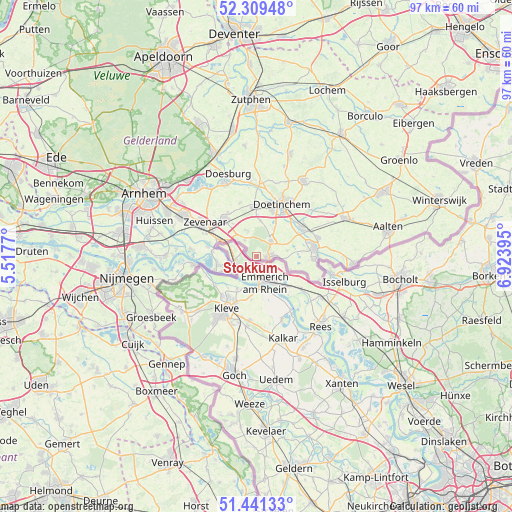
Stokkum GPS coordinates[2]
51° 52' 39" North, 6° 13' 14.988" East
| Map corner | latitude | longitude |
|---|---|---|
| Upper-left | 52.30948°, | 5.5177° |
| Center: | 51.8775°, | 6.22083° |
| Lower-right: | 51.44133°, | 6.92395° |
| Map W x H: | 96.5×96.5 km | = 60×60mi |
| max Lat: | 53.48025° ⇑59.8% North |
| Stokkum: | 51.8775° |
| min Lat: | ⇓40.2% South 50.76917° |
| min Long | Stokkum | max Long |
| 3.38611° | 6.22083° | 7.16528° |
| W 83.7%⇐ | ⇒16.3% E |
Elevation
Elevation of Stokkum is 18 m = 59 ft, and this is 3 m = 10 ft above average elevation for this country.
| Max E: |
203 m = 666 ft | 25.1% |
| Stokkum | 18 m 59 ft | |
| Avg. | 15 m = 49 ft | |
Min E: |
-6 m = -20 ft | 74.9% |
See also: Netherlands elevation on elevation.city.
Geographical zone
Stokkum is located in North temperate zone (between Tropic of Cancer and the Arctic Circle). Distance of this North polar circle is 1632.9 km =1014.6 mi to North.| Distance of | km | miles | from Stokkum |
|---|---|---|---|
| North Pole | 4238.8 | 2633.9 | to North |
| Arctic Circle | 1632.9 | 1014.6 | to North |
| Tropic Cancer | 3162.3 | 1965 | to South |
| Equator | 5768.2 | 3584.2 | to South |


Nearby cities:
15 places around Stokkum: (largest is in red/bold)
• 's-Heerenberg
2.6 km =1.6 mi,  91°
91°
• Aerdt
9.5 km =5.9 mi,  281°
281°
• Babberich
8.2 km =5.1 mi,  293°
293°
• Beek gem Montferland
4 km =2.5 mi,  324°
324°
• Braamt
5.9 km =3.7 mi,  30°
30°
• Etten
9 km =5.6 mi,  61°
61°
• Herwen
8.3 km =5.2 mi, 275°
• Kilder
6.7 km =4.2 mi,  6°
6°
• Lobith
7.2 km =4.5 mi,  256°
256°
• Loil
10 km =6.2 mi,  327°
327°
• Nieuw-Dijk
7.7 km =4.8 mi, 324°
• Spijk
5.6 km =3.5 mi,  235°
235°
• Terborg
10.3 km =6.4 mi, 62°
• Tolkamer
8.5 km =5.3 mi,  252°
252°
• Zeddam
3.9 km =2.4 mi,  42°
42°
Sources, notices
• [Note1] Compared only with cities in Netherlands existing in our database
• [Src1] Map data: © OpenStreetMap contributors (CC-BY-SA)
• [Src2] Other city data from geonames.org with taken over terms of usage.
• [Src3] Geographical zone / Annual Mean Temperature by Robert A. Rohde @ Wikipedia
