Aerdt geodata
Aerdt (Gelderland) is a populated place; located in Netherlands in Europe/Amsterdam (GMT+2) time zone. With population of 540 people, there are 1788 cities with bigger population in this country. Compared to other cities in Netherlands, 58% of cities are located further ↑North; 78.4% of cities are located further ←West and 67% of cities have lower elevation than Aerdt. Note1


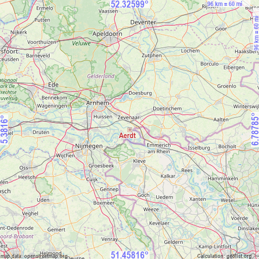
Aerdt GPS coordinates[2]
51° 53' 39.012" North, 6° 5' 4.992" East
| Map corner | latitude | longitude |
|---|---|---|
| Upper-left | 52.32599°, | 5.3816° |
| Center: | 51.89417°, | 6.08472° |
| Lower-right: | 51.45816°, | 6.78785° |
| Map W x H: | 96.5×96.5 km | = 60×60mi |
| max Lat: | 53.48025° ⇑58% North |
| Aerdt: | 51.89417° |
| min Lat: | ⇓42% South 50.76917° |
| min Long | Aerdt | max Long |
| 3.38611° | 6.08472° | 7.16528° |
| W 78.4%⇐ | ⇒21.6% E |
Elevation
Elevation of Aerdt is 13 m = 43 ft, and this is 2 m = 7 ft below average elevation for this country.
| Max E: |
203 m = 666 ft | 33% |
| Avg. | 15 m = 49 ft | |
| Aerdt | 13 m = 43 ft | |
Min E: |
-6 m = -20 ft | 67% |
See also: Netherlands elevation on elevation.city.
Geographical zone
Aerdt is located in North temperate zone (between Tropic of Cancer and the Arctic Circle). Distance of this North polar circle is 1631.1 km =1013.5 mi to North.| Distance of | km | miles | from Aerdt |
|---|---|---|---|
| North Pole | 4237 | 2632.7 | to North |
| Arctic Circle | 1631.1 | 1013.5 | to North |
| Tropic Cancer | 3164.2 | 1966.1 | to South |
| Equator | 5770.1 | 3585.4 | to South |


Nearby cities:
15 places around Aerdt: (largest is in red/bold)
• Babberich
2.3 km =1.4 mi,  50°
50°
• Beek gem Montferland
7.2 km =4.5 mi,  78°
78°
• Doornenburg
5.8 km =3.6 mi,  265°
265°
• Groessen
5.8 km =3.6 mi,  316°
316°
• Herwen
1.5 km =0.9 mi,  134°
134°
• Lobith
4.2 km =2.6 mi,  146°
146°
• Loil
7.6 km =4.7 mi,  30°
30°
• Nieuw-Dijk
6.5 km =4 mi, 48°
• Ooy
3.3 km =2.1 mi,  326°
326°
• Pannerden
3.2 km =2 mi,  263°
263°
• Spijk
6.9 km =4.3 mi,  136°
136°
• Stegeslag
5.5 km =3.4 mi,  343°
343°
• Tolkamer
4.5 km =2.8 mi,  164°
164°
• Zevenaar
4.1 km =2.5 mi,  346°
346°
• Zonnemaat
4.4 km =2.7 mi, 339°
Sources, notices
• [Note1] Compared only with cities in Netherlands existing in our database
• [Src1] Map data: © OpenStreetMap contributors (CC-BY-SA)
• [Src2] Other city data from geonames.org with taken over terms of usage.
• [Src3] Geographical zone / Annual Mean Temperature by Robert A. Rohde @ Wikipedia
