Sluis geodata
Sluis (Zeeland) is a populated place; located in Netherlands in Europe/Amsterdam (GMT+2) time zone. With population of 1,935 people, there are 982 cities with bigger population in this country. Compared to other cities in Netherlands, 89.2% of cities are located further ↑North; 100% of cities are located further →East and 50.6% of cities have higher elevation than Sluis. Note1


Sluis GPS coordinates[2]
51° 18' 29.988" North, 3° 23' 9.996" East
| Map corner | latitude | longitude |
|---|---|---|
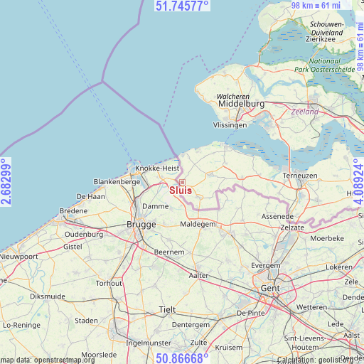
| Upper-left | 51.74577°, | 2.68299° |
| Center: | 51.30833°, | 3.38611° |
| Lower-right: | 50.86668°, | 4.08924° |
| Map W x H: | 97.7×97.7 km | = 60.7×60.7mi |
| max Lat: | 53.48025° ⇑89.2% North |
| Sluis: | 51.30833° |
| min Lat: | ⇓10.8% South 50.76917° |
| min Long | Sluis | max Long |
| 3.38611° | 3.38611° | 7.16528° |
| W 0%⇐ | ⇒100% E |
Elevation
Elevation of Sluis is 6 m = 20 ft, and this is 9 m = 30 ft below average elevation for this country.
| Max E: |
203 m = 666 ft | 50.6% |
| Avg. | 15 m = 49 ft | |
| Sluis | 6 m = 20 ft | |
Min E: |
-6 m = -20 ft | 49.4% |
See also: Netherlands elevation on elevation.city.
Geographical zone
Sluis is located in North temperate zone (between Tropic of Cancer and the Arctic Circle). Distance of this North polar circle is 1696.2 km =1054 mi to North.| Distance of | km | miles | from Sluis |
|---|---|---|---|
| North Pole | 4302.1 | 2673.2 | to North |
| Arctic Circle | 1696.2 | 1054 | to North |
| Tropic Cancer | 3099 | 1925.6 | to South |
| Equator | 5705 | 3544.9 | to South |


Nearby cities:
15 places around Sluis: (largest is in red/bold)
• Aardenburg
5.8 km =3.6 mi,  132°
132°
• Biggekerke
23.3 km =14.5 mi,  24°
24°
• Breskens
15.3 km =9.5 mi,  50°
50°
• Eede
7.8 km =4.8 mi,  149°
149°
• Groede
11.4 km =7.1 mi, 47°
• Hoofdplaat
20.4 km =12.7 mi,  70°
70°
• IJzendijke
16.1 km =10 mi,  84°
84°
• Koudekerke
22.5 km =14 mi,  31°
31°
• Lammerenburg
21.3 km =13.2 mi, 34°
• Oostburg
7.3 km =4.5 mi, 74°
• Schoondijke
12.8 km =8 mi, 66°
• Vlissingen
19.8 km =12.3 mi,  41°
41°
• West-Souburg
22.4 km =13.9 mi, 39°
• Westerzicht
22.1 km =13.7 mi, 39°
• Zoutelande
22.6 km =14 mi, 17°
Sources, notices
• [Note1] Compared only with cities in Netherlands existing in our database
• [Src1] Map data: © OpenStreetMap contributors (CC-BY-SA)
• [Src2] Other city data from geonames.org with taken over terms of usage.
• [Src3] Geographical zone / Annual Mean Temperature by Robert A. Rohde @ Wikipedia
