Oostermeenthe geodata
Oostermeenthe (Overijssel) is a section of populated place; located in Netherlands in Europe/Amsterdam (GMT+2) time zone. With population of 3,075 people, there are 740 cities with bigger population in this country. Compared to other cities in Netherlands, 79.7% of cities are located further ↓South; 80.7% of cities are located further ←West and 74.9% of cities have higher elevation than Oostermeenthe. Note1


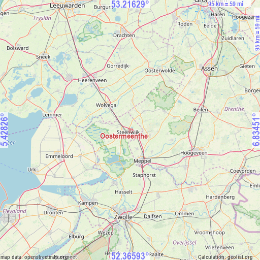
Oostermeenthe GPS coordinates[2]
52° 47' 35.484" North, 6° 7' 52.968" East
| Map corner | latitude | longitude |
|---|---|---|
| Upper-left | 53.21629°, | 5.42826° |
| Center: | 52.79319°, | 6.13138° |
| Lower-right: | 52.36593°, | 6.83451° |
| Map W x H: | 94.6×94.5 km | = 58.8×58.7mi |
| max Lat: | 53.48025° ⇑20.3% North |
| Oostermeenthe: | 52.79319° |
| min Lat: | ⇓79.7% South 50.76917° |
| min Long | Oostermeenthe | max Long |
| 3.38611° | 6.13138° | 7.16528° |
| W 80.7%⇐ | ⇒19.3% E |
Elevation
Elevation of Oostermeenthe is 2 m = 7 ft, and this is 13 m = 43 ft below average elevation for this country.
| Max E: |
203 m = 666 ft | 74.9% |
| Avg. | 15 m = 49 ft | |
| Oostermeenthe | 2 m = 7 ft | |
Min E: |
-6 m = -20 ft | 25.1% |
See also: Netherlands elevation on elevation.city.
Geographical zone
Oostermeenthe is located in North temperate zone (between Tropic of Cancer and the Arctic Circle). Distance of this North polar circle is 1531.1 km =951.4 mi to North.| Distance of | km | miles | from Oostermeenthe |
|---|---|---|---|
| North Pole | 4137 | 2570.6 | to North |
| Arctic Circle | 1531.1 | 951.4 | to North |
| Tropic Cancer | 3264.1 | 2028.2 | to South |
| Equator | 5870.1 | 3647.5 | to South |


Nearby cities:
15 places around Oostermeenthe: (largest is in red/bold)
• Darp
5.3 km =3.3 mi,  112°
112°
• De Blesse
8.2 km =5.1 mi,  312°
312°
• Giethoorn
6.9 km =4.3 mi,  210°
210°
• Havelte
7.8 km =4.8 mi, 109°
• Noordwolde
10.7 km =6.6 mi,  3°
3°
• Oldemarkt
11 km =6.8 mi,  286°
286°
• Steenwijk
1 km =0.6 mi,  228°
228°
• Steenwijkerwold
4.7 km =2.9 mi, 285°
• Steggerda
8.1 km =5 mi,  332°
332°
• Tuk
2.5 km =1.6 mi,  278°
278°
• Uffelte
10 km =6.2 mi,  92°
92°
• Vledder
8.7 km =5.4 mi,  36°
36°
• Wilhelminaoord
7.3 km =4.5 mi,  17°
17°
• Willemsoord
6 km =3.7 mi, 306°
• Zuidveen
2.4 km =1.5 mi,  223°
223°
Sources, notices
• [Note1] Compared only with cities in Netherlands existing in our database
• [Src1] Map data: © OpenStreetMap contributors (CC-BY-SA)
• [Src2] Other city data from geonames.org with taken over terms of usage.
• [Src3] Geographical zone / Annual Mean Temperature by Robert A. Rohde @ Wikipedia
