Sappemeer geodata
Sappemeer (Groningen) is a populated place; located in Netherlands in Europe/Amsterdam (GMT+2) time zone. With population of 8,298 people, there are 327 cities with bigger population in this country. Compared to other cities in Netherlands, 91.6% of cities are located further ↓South; 95.1% of cities are located further ←West and 74.9% of cities have higher elevation than Sappemeer. Note1


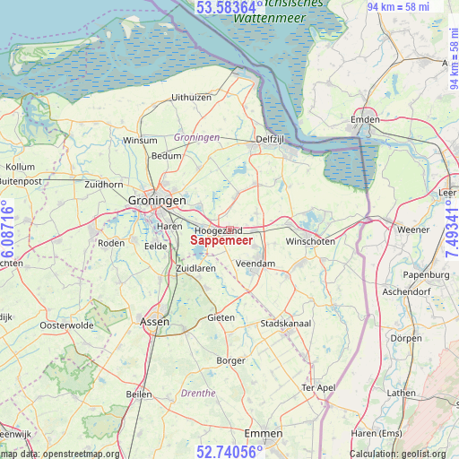
Sappemeer GPS coordinates[2]
53° 9' 51.012" North, 6° 47' 25.008" East
| Map corner | latitude | longitude |
|---|---|---|
| Upper-left | 53.58364°, | 6.08716° |
| Center: | 53.16417°, | 6.79028° |
| Lower-right: | 52.74056°, | 7.49341° |
| Map W x H: | 93.7×93.7 km | = 58.2×58.2mi |
| max Lat: | 53.48025° ⇑8.4% North |
| Sappemeer: | 53.16417° |
| min Lat: | ⇓91.6% South 50.76917° |
| min Long | Sappemeer | max Long |
| 3.38611° | 6.79028° | 7.16528° |
| W 95.1%⇐ | ⇒4.9% E |
Elevation
Elevation of Sappemeer is 2 m = 7 ft, and this is 13 m = 43 ft below average elevation for this country.
| Max E: |
203 m = 666 ft | 74.9% |
| Avg. | 15 m = 49 ft | |
| Sappemeer | 2 m = 7 ft | |
Min E: |
-6 m = -20 ft | 25.1% |
See also: Netherlands elevation on elevation.city.
Geographical zone
Sappemeer is located in North temperate zone (between Tropic of Cancer and the Arctic Circle). Distance of this North polar circle is 1489.9 km =925.8 mi to North.| Distance of | km | miles | from Sappemeer |
|---|---|---|---|
| North Pole | 4095.8 | 2545 | to North |
| Arctic Circle | 1489.9 | 925.8 | to North |
| Tropic Cancer | 3305.4 | 2053.9 | to South |
| Equator | 5911.3 | 3673.1 | to South |


Nearby cities:
15 places around Sappemeer: (largest is in red/bold)
• Foxhol
4.6 km =2.9 mi,  274°
274°
• Froombosch
3.4 km =2.1 mi,  349°
349°
• Harkstede
8.2 km =5.1 mi,  311°
311°
• Hellum
8.9 km =5.5 mi,  21°
21°
• Hoogezand
2 km =1.2 mi,  261°
261°
• Kiel-Windeweer
5.8 km =3.6 mi,  187°
187°
• Kolham
3.7 km =2.3 mi,  303°
303°
• Martenshoek
4 km =2.5 mi, 268°
• Meerwijck
5.5 km =3.4 mi,  249°
249°
• Noordbroek
6.5 km =4 mi,  58°
58°
• Scharmer
7.2 km =4.5 mi, 308°
• Schildwolde
7.9 km =4.9 mi,  12°
12°
• Slochteren
6.4 km =4 mi, 9°
• Veendam
8.7 km =5.4 mi,  137°
137°
• Zuidbroek
4.7 km =2.9 mi,  91°
91°
Sources, notices
• [Note1] Compared only with cities in Netherlands existing in our database
• [Src1] Map data: © OpenStreetMap contributors (CC-BY-SA)
• [Src2] Other city data from geonames.org with taken over terms of usage.
• [Src3] Geographical zone / Annual Mean Temperature by Robert A. Rohde @ Wikipedia
