Hegelsom geodata
Hegelsom (Limburg) is a populated place; located in Netherlands in Europe/Amsterdam (GMT+2) time zone. With population of 1,185 people, there are 1291 cities with bigger population in this country. Compared to other cities in Netherlands, 84.5% of cities are located further ↑North; 75.2% of cities are located further ←West and 86.2% of cities have lower elevation than Hegelsom. Note1


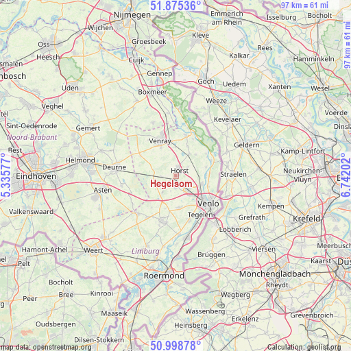
Hegelsom GPS coordinates[2]
51° 26' 21.012" North, 6° 2' 20.004" East
| Map corner | latitude | longitude |
|---|---|---|
| Upper-left | 51.87536°, | 5.33577° |
| Center: | 51.43917°, | 6.03889° |
| Lower-right: | 50.99878°, | 6.74202° |
| Map W x H: | 97.5×97.5 km | = 60.6×60.6mi |
| max Lat: | 53.48025° ⇑84.5% North |
| Hegelsom: | 51.43917° |
| min Lat: | ⇓15.5% South 50.76917° |
| min Long | Hegelsom | max Long |
| 3.38611° | 6.03889° | 7.16528° |
| W 75.2%⇐ | ⇒24.8% E |
Elevation
Elevation of Hegelsom is 28 m = 92 ft, and this is 13 m = 43 ft above average elevation for this country.
| Max E: |
203 m = 666 ft | 13.8% |
| Hegelsom | 28 m 92 ft | |
| Avg. | 15 m = 49 ft | |
Min E: |
-6 m = -20 ft | 86.2% |
See also: Netherlands elevation on elevation.city.
Geographical zone
Hegelsom is located in North temperate zone (between Tropic of Cancer and the Arctic Circle). Distance of this North polar circle is 1681.7 km =1045 mi to North.| Distance of | km | miles | from Hegelsom |
|---|---|---|---|
| North Pole | 4287.6 | 2664.2 | to North |
| Arctic Circle | 1681.7 | 1045 | to North |
| Tropic Cancer | 3113.6 | 1934.7 | to South |
| Equator | 5719.5 | 3553.9 | to South |


Nearby cities:
15 places around Hegelsom: (largest is in red/bold)
• America
4.1 km =2.5 mi,  266°
266°
• Boekend
8.7 km =5.4 mi,  141°
141°
• Castenray
5.6 km =3.5 mi,  357°
357°
• Kronenberg
3.7 km =2.3 mi,  226°
226°
• Leunen
8.9 km =5.5 mi,  332°
332°
• Lottum
8.8 km =5.5 mi,  73°
73°
• Maasbree
9.1 km =5.7 mi,  175°
175°
• Meerlo
8.8 km =5.5 mi,  21°
21°
• Melderslo
4.1 km =2.5 mi,  52°
52°
• Meterik
2 km =1.2 mi, 331°
• Oirlo
8.1 km =5 mi, 359°
• Sevenum
3 km =1.9 mi, 181°
• Swolgen
8.1 km =5 mi,  42°
42°
• Tienray
7.3 km =4.5 mi,  31°
31°
• Veulen
7.7 km =4.8 mi,  308°
308°
Sources, notices
• [Note1] Compared only with cities in Netherlands existing in our database
• [Src1] Map data: © OpenStreetMap contributors (CC-BY-SA)
• [Src2] Other city data from geonames.org with taken over terms of usage.
• [Src3] Geographical zone / Annual Mean Temperature by Robert A. Rohde @ Wikipedia
