Loppersum geodata
Loppersum (Groningen) is a populated place; located in Netherlands in Europe/Amsterdam (GMT+2) time zone. With population of 2,365 people, there are 875 cities with bigger population in this country. Compared to other cities in Netherlands, 98.3% of cities are located further ↓South; 94.5% of cities are located further ←West and 74.9% of cities have higher elevation than Loppersum. Note1


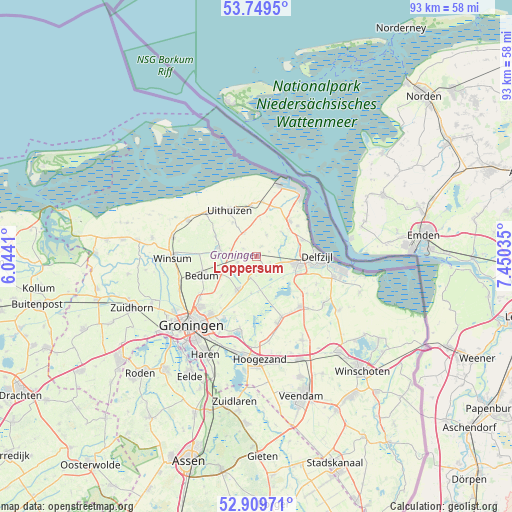
Loppersum GPS coordinates[2]
53° 19' 54.012" North, 6° 44' 49.992" East
| Map corner | latitude | longitude |
|---|---|---|
| Upper-left | 53.7495°, | 6.0441° |
| Center: | 53.33167°, | 6.74722° |
| Lower-right: | 52.90971°, | 7.45035° |
| Map W x H: | 93.4×93.4 km | = 58×58mi |
| max Lat: | 53.48025° ⇑1.7% North |
| Loppersum: | 53.33167° |
| min Lat: | ⇓98.3% South 50.76917° |
| min Long | Loppersum | max Long |
| 3.38611° | 6.74722° | 7.16528° |
| W 94.5%⇐ | ⇒5.5% E |
Elevation
Elevation of Loppersum is 2 m = 7 ft, and this is 13 m = 43 ft below average elevation for this country.
| Max E: |
203 m = 666 ft | 74.9% |
| Avg. | 15 m = 49 ft | |
| Loppersum | 2 m = 7 ft | |
Min E: |
-6 m = -20 ft | 25.1% |
See also: Netherlands elevation on elevation.city.
Geographical zone
Loppersum is located in North temperate zone (between Tropic of Cancer and the Arctic Circle). Distance of this North polar circle is 1471.2 km =914.2 mi to North.| Distance of | km | miles | from Loppersum |
|---|---|---|---|
| North Pole | 4077.1 | 2533.4 | to North |
| Arctic Circle | 1471.2 | 914.2 | to North |
| Tropic Cancer | 3324 | 2065.4 | to South |
| Equator | 5929.9 | 3684.7 | to South |


Nearby cities:
15 places around Loppersum: (largest is in red/bold)
• Appingedam
7.5 km =4.7 mi,  98°
98°
• Bedum
10.2 km =6.3 mi,  250°
250°
• Bierum
9.4 km =5.8 mi,  52°
52°
• Holwierde
8.9 km =5.5 mi,  70°
70°
• Kantens
8.4 km =5.2 mi,  296°
296°
• Middelstum
7.2 km =4.5 mi,  283°
283°
• Onderdendam
10.4 km =6.5 mi,  271°
271°
• Roodeschool
10 km =6.2 mi,  7°
7°
• Spijk
8.8 km =5.5 mi,  42°
42°
• Stedum
3.6 km =2.2 mi, 253°
• Ten Boer
7.1 km =4.4 mi,  209°
209°
• Ten Post
4 km =2.5 mi,  198°
198°
• Tuikwerd
10.3 km =6.4 mi, 99°
• Uithuizen
9.8 km =6.1 mi,  328°
328°
• Uithuizermeeden
9.3 km =5.8 mi,  350°
350°
Sources, notices
• [Note1] Compared only with cities in Netherlands existing in our database
• [Src1] Map data: © OpenStreetMap contributors (CC-BY-SA)
• [Src2] Other city data from geonames.org with taken over terms of usage.
• [Src3] Geographical zone / Annual Mean Temperature by Robert A. Rohde @ Wikipedia
