Bierum geodata
Bierum (Groningen) is a populated place; located in Netherlands in Europe/Amsterdam (GMT+2) time zone. With population of 605 people, there are 1718 cities with bigger population in this country. Compared to other cities in Netherlands, 99.4% of cities are located further ↓South; 96.1% of cities are located further ←West and 83.9% of cities have higher elevation than Bierum. Note1


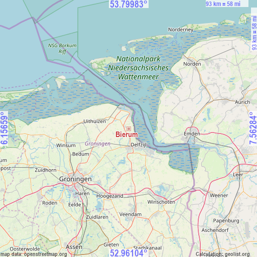
Bierum GPS coordinates[2]
53° 22' 57" North, 6° 51' 34.992" East
| Map corner | latitude | longitude |
|---|---|---|
| Upper-left | 53.79983°, | 6.15659° |
| Center: | 53.3825°, | 6.85972° |
| Lower-right: | 52.96104°, | 7.56284° |
| Map W x H: | 93.3×93.3 km | = 58×58mi |
| max Lat: | 53.48025° ⇑0.6% North |
| Bierum: | 53.3825° |
| min Lat: | ⇓99.4% South 50.76917° |
| min Long | Bierum | max Long |
| 3.38611° | 6.85972° | 7.16528° |
| W 96.1%⇐ | ⇒3.9% E |
Elevation
Elevation of Bierum is 1 m = 3 ft, and this is 14 m = 46 ft below average elevation for this country.
| Max E: |
203 m = 666 ft | 83.9% |
| Avg. | 15 m = 49 ft | |
| Bierum | 1 m = 3 ft | |
Min E: |
-6 m = -20 ft | 16.1% |
See also: Netherlands elevation on elevation.city.
Geographical zone
Bierum is located in North temperate zone (between Tropic of Cancer and the Arctic Circle). Distance of this North polar circle is 1465.6 km =910.7 mi to North.| Distance of | km | miles | from Bierum |
|---|---|---|---|
| North Pole | 4071.5 | 2529.9 | to North |
| Arctic Circle | 1465.6 | 910.7 | to North |
| Tropic Cancer | 3329.7 | 2069 | to South |
| Equator | 5935.6 | 3688.2 | to South |


Nearby cities:
15 places around Bierum: (largest is in red/bold)
• Appingedam
6.8 km =4.2 mi,  180°
180°
• Delfzijl
7 km =4.3 mi,  146°
146°
• Farmsum
8.1 km =5 mi, 146°
• Holwierde
2.8 km =1.7 mi,  161°
161°
• Loppersum
9.4 km =5.8 mi,  232°
232°
• Middelstum
15 km =9.3 mi,  254°
254°
• Roodeschool
7.5 km =4.7 mi,  304°
304°
• Siddeburen
14.7 km =9.1 mi, 177°
• Spijk
1.7 km =1.1 mi, 299°
• Stedum
12.8 km =8 mi,  238°
238°
• Ten Post
12.9 km =8 mi,  222°
222°
• Tuikwerd
7.8 km =4.8 mi, 159°
• Uithuizen
12.8 km =8 mi,  282°
282°
• Uithuizermeeden
9.7 km =6 mi,  291°
291°
• Wagenborgen
14.9 km =9.3 mi, 160°
Sources, notices
• [Note1] Compared only with cities in Netherlands existing in our database
• [Src1] Map data: © OpenStreetMap contributors (CC-BY-SA)
• [Src2] Other city data from geonames.org with taken over terms of usage.
• [Src3] Geographical zone / Annual Mean Temperature by Robert A. Rohde @ Wikipedia
