Roodeschool geodata
Roodeschool (Groningen) is a populated place; located in Netherlands in Europe/Amsterdam (GMT+2) time zone. With population of 875 people, there are 1479 cities with bigger population in this country. Compared to other cities in Netherlands, 99.8% of cities are located further ↓South; 94.9% of cities are located further ←West and 83.9% of cities have higher elevation than Roodeschool. Note1


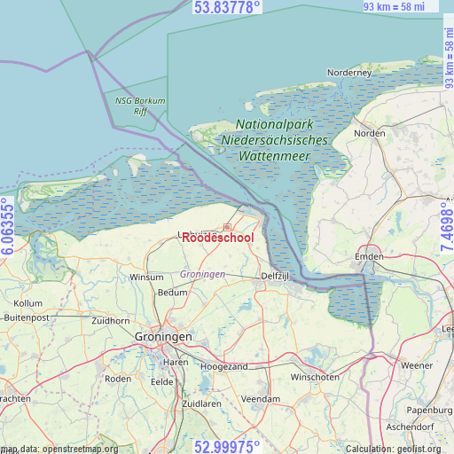
Roodeschool GPS coordinates[2]
53° 25' 14.988" North, 6° 46' 0.012" East
| Map corner | latitude | longitude |
|---|---|---|
| Upper-left | 53.83778°, | 6.06355° |
| Center: | 53.42083°, | 6.76667° |
| Lower-right: | 52.99975°, | 7.4698° |
| Map W x H: | 93.2×93.2 km | = 57.9×57.9mi |
| max Lat: | 53.48025° ⇑0.2% North |
| Roodeschool: | 53.42083° |
| min Lat: | ⇓99.8% South 50.76917° |
| min Long | Roodeschool | max Long |
| 3.38611° | 6.76667° | 7.16528° |
| W 94.9%⇐ | ⇒5.1% E |
Elevation
Elevation of Roodeschool is 1 m = 3 ft, and this is 14 m = 46 ft below average elevation for this country.
| Max E: |
203 m = 666 ft | 83.9% |
| Avg. | 15 m = 49 ft | |
| Roodeschool | 1 m = 3 ft | |
Min E: |
-6 m = -20 ft | 16.1% |
See also: Netherlands elevation on elevation.city.
Geographical zone
Roodeschool is located in North temperate zone (between Tropic of Cancer and the Arctic Circle). Distance of this North polar circle is 1461.3 km =908 mi to North.| Distance of | km | miles | from Roodeschool |
|---|---|---|---|
| North Pole | 4067.2 | 2527.2 | to North |
| Arctic Circle | 1461.3 | 908 | to North |
| Tropic Cancer | 3333.9 | 2071.6 | to South |
| Equator | 5939.8 | 3690.8 | to South |


Nearby cities:
15 places around Roodeschool: (largest is in red/bold)
• Appingedam
12.6 km =7.8 mi,  151°
151°
• Bierum
7.5 km =4.7 mi,  124°
124°
• Delfzijl
14.2 km =8.8 mi,  135°
135°
• Holwierde
9.9 km =6.2 mi,  134°
134°
• Kantens
10.7 km =6.6 mi,  235°
235°
• Loppersum
10 km =6.2 mi,  187°
187°
• Middelstum
11.7 km =7.3 mi,  225°
225°
• Spijk
5.8 km =3.6 mi, 126°
• Stedum
11.9 km =7.4 mi,  203°
203°
• Ten Post
14 km =8.7 mi, 190°
• Tuikwerd
14.6 km =9.1 mi, 142°
• Uithuizen
6.5 km =4 mi,  256°
256°
• Uithuizermeeden
2.9 km =1.8 mi, 255°
• Usquert
10.5 km =6.5 mi, 258°
• Warffum
14.2 km =8.8 mi, 257°
Sources, notices
• [Note1] Compared only with cities in Netherlands existing in our database
• [Src1] Map data: © OpenStreetMap contributors (CC-BY-SA)
• [Src2] Other city data from geonames.org with taken over terms of usage.
• [Src3] Geographical zone / Annual Mean Temperature by Robert A. Rohde @ Wikipedia
