Langezwaag geodata
Langezwaag (Friesland) is a populated place; located in Netherlands in Europe/Amsterdam (GMT+2) time zone. With population of 615 people, there are 1704 cities with bigger population in this country. Compared to other cities in Netherlands, 85.1% of cities are located further ↓South; 73.3% of cities are located further ←West and 74.9% of cities have higher elevation than Langezwaag. Note1


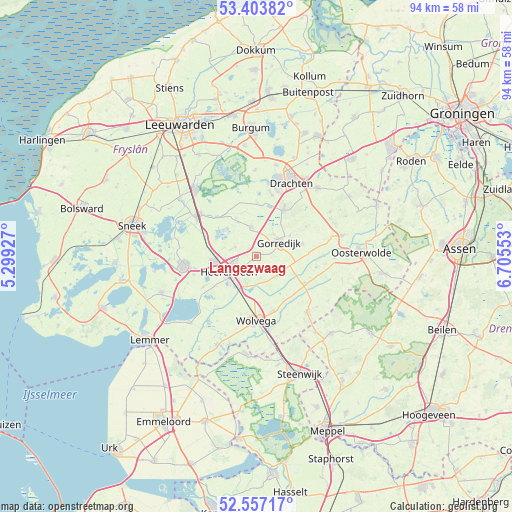
Langezwaag GPS coordinates[2]
52° 58' 57.252" North, 6° 0' 8.64" East
| Map corner | latitude | longitude |
|---|---|---|
| Upper-left | 53.40382°, | 5.29927° |
| Center: | 52.98257°, | 6.0024° |
| Lower-right: | 52.55717°, | 6.70553° |
| Map W x H: | 94.1×94.1 km | = 58.5×58.5mi |
| max Lat: | 53.48025° ⇑14.9% North |
| Langezwaag: | 52.98257° |
| min Lat: | ⇓85.1% South 50.76917° |
| min Long | Langezwaag | max Long |
| 3.38611° | 6.0024° | 7.16528° |
| W 73.3%⇐ | ⇒26.7% E |
Elevation
Elevation of Langezwaag is 2 m = 7 ft, and this is 13 m = 43 ft below average elevation for this country.
| Max E: |
203 m = 666 ft | 74.9% |
| Avg. | 15 m = 49 ft | |
| Langezwaag | 2 m = 7 ft | |
Min E: |
-6 m = -20 ft | 25.1% |
See also: Netherlands elevation on elevation.city.
Geographical zone
Langezwaag is located in North temperate zone (between Tropic of Cancer and the Arctic Circle). Distance of this North polar circle is 1510.1 km =938.3 mi to North.| Distance of | km | miles | from Langezwaag |
|---|---|---|---|
| North Pole | 4116 | 2557.6 | to North |
| Arctic Circle | 1510.1 | 938.3 | to North |
| Tropic Cancer | 3285.2 | 2041.3 | to South |
| Equator | 5891.1 | 3660.6 | to South |


Nearby cities:
15 places around Langezwaag: (largest is in red/bold)
• De Greiden
7 km =4.3 mi,  238°
238°
• De Knipe
2.6 km =1.6 mi,  232°
232°
• Gorredijk
4.9 km =3 mi,  57°
57°
• Heerenveen
6.2 km =3.9 mi,  245°
245°
• Jubbega
8.3 km =5.2 mi,  73°
73°
• Katlijk
4.1 km =2.5 mi,  170°
170°
• Lippenhuizen
7.3 km =4.5 mi, 56°
• Mildam
5.2 km =3.2 mi,  180°
180°
• Nieuwehorne
5.4 km =3.4 mi,  130°
130°
• Oranjewoud
5.4 km =3.4 mi,  220°
220°
• Oudehorne
5.9 km =3.7 mi,  112°
112°
• Oudeschoot
6.3 km =3.9 mi,  209°
209°
• Terwispel
5.1 km =3.2 mi,  36°
36°
• Tijnje
5.4 km =3.4 mi,  352°
352°
• Tjalleberd
4.2 km =2.6 mi,  292°
292°
Sources, notices
• [Note1] Compared only with cities in Netherlands existing in our database
• [Src1] Map data: © OpenStreetMap contributors (CC-BY-SA)
• [Src2] Other city data from geonames.org with taken over terms of usage.
• [Src3] Geographical zone / Annual Mean Temperature by Robert A. Rohde @ Wikipedia
