Tijnje geodata
Tijnje (Friesland) is a populated place; located in Netherlands in Europe/Amsterdam (GMT+2) time zone. With population of 1,120 people, there are 1319 cities with bigger population in this country. Compared to other cities in Netherlands, 86.4% of cities are located further ↓South; 72.2% of cities are located further ←West and 91.3% of cities have higher elevation than Tijnje. Note1


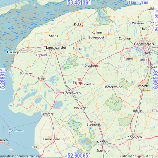
Tijnje GPS coordinates[2]
53° 1' 50.088" North, 5° 59' 30.948" East
| Map corner | latitude | longitude |
|---|---|---|
| Upper-left | 53.45136°, | 5.28881° |
| Center: | 53.03058°, | 5.99193° |
| Lower-right: | 52.60565°, | 6.69506° |
| Map W x H: | 94×94 km | = 58.4×58.4mi |
| max Lat: | 53.48025° ⇑13.6% North |
| Tijnje: | 53.03058° |
| min Lat: | ⇓86.4% South 50.76917° |
| min Long | Tijnje | max Long |
| 3.38611° | 5.99193° | 7.16528° |
| W 72.2%⇐ | ⇒27.8% E |
Elevation
Elevation of Tijnje is 0 m = 0 ft, and this is 15 m = 49 ft below average elevation for this country.
| Max E: |
203 m = 666 ft | 91.3% |
| Avg. | 15 m = 49 ft | |
| Tijnje | 0 m = 0 ft | |
Min E: |
-6 m = -20 ft | 8.7% |
See also: Netherlands elevation on elevation.city.
Geographical zone
Tijnje is located in North temperate zone (between Tropic of Cancer and the Arctic Circle). Distance of this North polar circle is 1504.7 km =935 mi to North.| Distance of | km | miles | from Tijnje |
|---|---|---|---|
| North Pole | 4110.6 | 2554.2 | to North |
| Arctic Circle | 1504.7 | 935 | to North |
| Tropic Cancer | 3290.5 | 2044.6 | to South |
| Equator | 5896.4 | 3663.9 | to South |


Nearby cities:
15 places around Tijnje: (largest is in red/bold)
• Aldeboarn
6.5 km =4 mi,  289°
289°
• Beetsterzwaag
6.5 km =4 mi,  60°
60°
• Boornbergum
6.8 km =4.2 mi,  31°
31°
• De Drait
9 km =5.6 mi, 34°
• De Knipe
7.1 km =4.4 mi,  191°
191°
• De Wilgen
8.2 km =5.1 mi,  20°
20°
• Gorredijk
5.5 km =3.4 mi,  118°
118°
• Heerenveen
9.3 km =5.8 mi,  211°
211°
• Jubbega
9.2 km =5.7 mi,  108°
108°
• Katlijk
9.5 km =5.9 mi,  171°
171°
• Langezwaag
5.4 km =3.4 mi, 172°
• Lippenhuizen
6.9 km =4.3 mi,  101°
101°
• Nes
9.6 km =6 mi,  284°
284°
• Terwispel
3.9 km =2.4 mi, 107°
• Tjalleberd
4.9 km =3 mi,  220°
220°
Sources, notices
• [Note1] Compared only with cities in Netherlands existing in our database
• [Src1] Map data: © OpenStreetMap contributors (CC-BY-SA)
• [Src2] Other city data from geonames.org with taken over terms of usage.
• [Src3] Geographical zone / Annual Mean Temperature by Robert A. Rohde @ Wikipedia
