Ypenburg geodata
Ypenburg (South Holland) is a populated place; located in Netherlands in Europe/Amsterdam (GMT+2) time zone. With population of 30,000 people, there are 105 cities with bigger population in this country. Compared to other cities in Netherlands, 51.3% of cities are located further ↓South; 92.5% of cities are located further →East and 99.9% of cities have higher elevation than Ypenburg. Note1


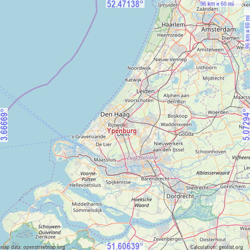
Ypenburg GPS coordinates[2]
52° 2' 27.528" North, 4° 22' 11.316" East
| Map corner | latitude | longitude |
|---|---|---|
| Upper-left | 52.47138°, | 3.66669° |
| Center: | 52.04098°, | 4.36981° |
| Lower-right: | 51.60639°, | 5.07294° |
| Map W x H: | 96.2×96.2 km | = 59.8×59.8mi |
| max Lat: | 53.48025° ⇑48.7% North |
| Ypenburg: | 52.04098° |
| min Lat: | ⇓51.3% South 50.76917° |
| min Long | Ypenburg | max Long |
| 3.38611° | 4.36981° | 7.16528° |
| W 7.5%⇐ | ⇒92.5% E |
Elevation
Elevation of Ypenburg is -4 m = -13 ft, and this is 19 m = 62 ft below average elevation for this country.
| Max E: |
203 m = 666 ft | 99.9% |
| Avg. | 15 m = 49 ft | |
| Ypenburg | -4 m = -13 ft | |
Min E: |
-6 m = -20 ft | 0.1% |
See also: Netherlands elevation on elevation.city.
Geographical zone
Ypenburg is located in North temperate zone (between Tropic of Cancer and the Arctic Circle). Distance of this North polar circle is 1614.8 km =1003.4 mi to North.| Distance of | km | miles | from Ypenburg |
|---|---|---|---|
| North Pole | 4220.6 | 2622.6 | to North |
| Arctic Circle | 1614.8 | 1003.4 | to North |
| Tropic Cancer | 3180.5 | 1976.3 | to South |
| Equator | 5786.4 | 3595.5 | to South |


Nearby cities:
15 places around Ypenburg: (largest is in red/bold)
• Delft
3.9 km =2.4 mi,  194°
194°
• Driemanspolder
8 km =5 mi,  81°
81°
• Duinzigt
7.7 km =4.8 mi,  336°
336°
• Essesteijn
4.9 km =3 mi,  2°
2°
• Kerkehout
7.7 km =4.8 mi, 4°
• Noordeinde
8.2 km =5.1 mi,  109°
109°
• Pijnacker
4.7 km =2.9 mi,  120°
120°
• Plaspoelpolder
2.6 km =1.6 mi,  264°
264°
• Rijswijk
3.1 km =1.9 mi, 260°
• Schipluiden
8.2 km =5.1 mi,  207°
207°
• Sion
4.3 km =2.7 mi,  225°
225°
• Spoorwijk
4.1 km =2.5 mi,  289°
289°
• Strijp
4.8 km =3 mi, 256°
• The Hague
6.3 km =3.9 mi,  309°
309°
• Voorburg
3.8 km =2.4 mi,  349°
349°
Sources, notices
• [Note1] Compared only with cities in Netherlands existing in our database
• [Src1] Map data: © OpenStreetMap contributors (CC-BY-SA)
• [Src2] Other city data from geonames.org with taken over terms of usage.
• [Src3] Geographical zone / Annual Mean Temperature by Robert A. Rohde @ Wikipedia
