Heumen geodata
Heumen (Gelderland) is a populated place; located in Netherlands in Europe/Amsterdam (GMT+2) time zone. With population of 1,010 people, there are 1391 cities with bigger population in this country. Compared to other cities in Netherlands, 66.3% of cities are located further ↑North; 60.9% of cities are located further ←West and 62% of cities have lower elevation than Heumen. Note1


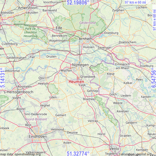
Heumen GPS coordinates[2]
51° 45' 54" North, 5° 50' 39.984" East
| Map corner | latitude | longitude |
|---|---|---|
| Upper-left | 52.19806°, | 5.14131° |
| Center: | 51.765°, | 5.84444° |
| Lower-right: | 51.32774°, | 6.54756° |
| Map W x H: | 96.8×96.8 km | = 60.1×60.1mi |
| max Lat: | 53.48025° ⇑66.3% North |
| Heumen: | 51.765° |
| min Lat: | ⇓33.7% South 50.76917° |
| min Long | Heumen | max Long |
| 3.38611° | 5.84444° | 7.16528° |
| W 60.9%⇐ | ⇒39.1% E |
Elevation
Elevation of Heumen is 11 m = 36 ft, and this is 4 m = 13 ft below average elevation for this country.
| Max E: |
203 m = 666 ft | 38% |
| Avg. | 15 m = 49 ft | |
| Heumen | 11 m = 36 ft | |
Min E: |
-6 m = -20 ft | 62% |
See also: Netherlands elevation on elevation.city.
Geographical zone
Heumen is located in North temperate zone (between Tropic of Cancer and the Arctic Circle). Distance of this North polar circle is 1645.4 km =1022.4 mi to North.| Distance of | km | miles | from Heumen |
|---|---|---|---|
| North Pole | 4251.3 | 2641.6 | to North |
| Arctic Circle | 1645.4 | 1022.4 | to North |
| Tropic Cancer | 3149.8 | 1957.2 | to South |
| Equator | 5755.7 | 3576.4 | to South |


Nearby cities:
15 places around Heumen: (largest is in red/bold)
• Alverna
7.3 km =4.5 mi,  306°
306°
• Beers
4.5 km =2.8 mi,  194°
194°
• Berg en Dal
8 km =5 mi,  38°
38°
• Brakkenstein
5.6 km =3.5 mi,  15°
15°
• Bredeweg
6.7 km =4.2 mi,  94°
94°
• Cuijk
4.5 km =2.8 mi,  147°
147°
• Grave
7.3 km =4.5 mi,  264°
264°
• Groesbeek
6.4 km =4 mi,  78°
78°
• Hatert
4.7 km =2.9 mi,  348°
348°
• Heilig Landstichting
6.6 km =4.1 mi, 23°
• Hengstdal
8.1 km =5 mi, 19°
• Mook
2.9 km =1.8 mi,  118°
118°
• Nederasselt
6.9 km =4.3 mi,  276°
276°
• Overasselt
3.9 km =2.4 mi, 261°
• Vianen
5.3 km =3.3 mi,  170°
170°
Sources, notices
• [Note1] Compared only with cities in Netherlands existing in our database
• [Src1] Map data: © OpenStreetMap contributors (CC-BY-SA)
• [Src2] Other city data from geonames.org with taken over terms of usage.
• [Src3] Geographical zone / Annual Mean Temperature by Robert A. Rohde @ Wikipedia
