Brakkenstein geodata
Brakkenstein (Gelderland) is a section of populated place; located in Netherlands in Europe/Amsterdam (GMT+2) time zone. With population of 3,755 people, there are 630 cities with bigger population in this country. Compared to other cities in Netherlands, 63.7% of cities are located further ↑North; 61.7% of cities are located further ←West and 83.5% of cities have lower elevation than Brakkenstein. Note1


Brakkenstein GPS coordinates[2]
51° 48' 47.664" North, 5° 51' 55.404" East
| Map corner | latitude | longitude |
|---|---|---|
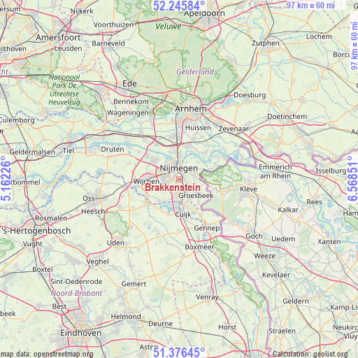
| Upper-left | 52.24584°, | 5.16226° |
| Center: | 51.81324°, | 5.86539° |
| Lower-right: | 51.37645°, | 6.56851° |
| Map W x H: | 96.7×96.7 km | = 60.1×60.1mi |
| max Lat: | 53.48025° ⇑63.7% North |
| Brakkenstein: | 51.81324° |
| min Lat: | ⇓36.3% South 50.76917° |
| min Long | Brakkenstein | max Long |
| 3.38611° | 5.86539° | 7.16528° |
| W 61.7%⇐ | ⇒38.3% E |
Elevation
Elevation of Brakkenstein is 25 m = 82 ft, and this is 10 m = 33 ft above average elevation for this country.
| Max E: |
203 m = 666 ft | 16.5% |
| Brakkenstein | 25 m 82 ft | |
| Avg. | 15 m = 49 ft | |
Min E: |
-6 m = -20 ft | 83.5% |
See also: Netherlands elevation on elevation.city.
Geographical zone
Brakkenstein is located in North temperate zone (between Tropic of Cancer and the Arctic Circle). Distance of this North polar circle is 1640.1 km =1019.1 mi to North.| Distance of | km | miles | from Brakkenstein |
|---|---|---|---|
| North Pole | 4246 | 2638.3 | to North |
| Arctic Circle | 1640.1 | 1019.1 | to North |
| Tropic Cancer | 3155.2 | 1960.5 | to South |
| Equator | 5761.1 | 3579.8 | to South |


Nearby cities:
15 places around Brakkenstein: (largest is in red/bold)
• Alverna
7.3 km =4.5 mi,  262°
262°
• Berg en Dal
3.6 km =2.2 mi,  75°
75°
• Bredeweg
7.9 km =4.9 mi,  138°
138°
• Groesbeek
6.3 km =3.9 mi,  129°
129°
• Hatert
2.5 km =1.6 mi,  252°
252°
• Hees
4 km =2.5 mi,  320°
320°
• Heilig Landstichting
1.4 km =0.9 mi,  61°
61°
• Hengstdal
2.6 km =1.6 mi,  28°
28°
• Heumen
5.6 km =3.5 mi,  195°
195°
• Hunnerberg
3.3 km =2.1 mi,  15°
15°
• Lent
5.4 km =3.4 mi,  0°
0°
• Lindenholt
5.4 km =3.4 mi,  293°
293°
• Mook
6.8 km =4.2 mi,  170°
170°
• Nijmegen
3.4 km =2.1 mi,  345°
345°
• Ooij
6.8 km =4.2 mi,  47°
47°
Sources, notices
• [Note1] Compared only with cities in Netherlands existing in our database
• [Src1] Map data: © OpenStreetMap contributors (CC-BY-SA)
• [Src2] Other city data from geonames.org with taken over terms of usage.
• [Src3] Geographical zone / Annual Mean Temperature by Robert A. Rohde @ Wikipedia
