Alverna geodata
Alverna (Gelderland) is a populated place; located in Netherlands in Europe/Amsterdam (GMT+2) time zone. With population of 1,595 people, there are 1084 cities with bigger population in this country. Compared to other cities in Netherlands, 64.5% of cities are located further ↑North; 55.1% of cities are located further ←West and 59.4% of cities have lower elevation than Alverna. Note1


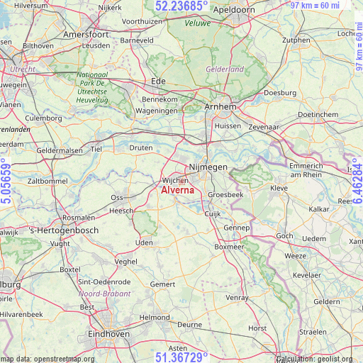
Alverna GPS coordinates[2]
51° 48' 15.012" North, 5° 45' 34.992" East
| Map corner | latitude | longitude |
|---|---|---|
| Upper-left | 52.23685°, | 5.05659° |
| Center: | 51.80417°, | 5.75972° |
| Lower-right: | 51.36729°, | 6.46284° |
| Map W x H: | 96.7×96.7 km | = 60.1×60.1mi |
| max Lat: | 53.48025° ⇑64.5% North |
| Alverna: | 51.80417° |
| min Lat: | ⇓35.5% South 50.76917° |
| min Long | Alverna | max Long |
| 3.38611° | 5.75972° | 7.16528° |
| W 55.1%⇐ | ⇒44.9% E |
Elevation
Elevation of Alverna is 10 m = 33 ft, and this is 5 m = 16 ft below average elevation for this country.
| Max E: |
203 m = 666 ft | 40.6% |
| Avg. | 15 m = 49 ft | |
| Alverna | 10 m = 33 ft | |
Min E: |
-6 m = -20 ft | 59.4% |
See also: Netherlands elevation on elevation.city.
Geographical zone
Alverna is located in North temperate zone (between Tropic of Cancer and the Arctic Circle). Distance of this North polar circle is 1641.1 km =1019.7 mi to North.| Distance of | km | miles | from Alverna |
|---|---|---|---|
| North Pole | 4247 | 2639 | to North |
| Arctic Circle | 1641.1 | 1019.7 | to North |
| Tropic Cancer | 3154.2 | 1959.9 | to South |
| Equator | 5760.1 | 3579.2 | to South |


Nearby cities:
15 places around Alverna: (largest is in red/bold)
• Bergharen
8.1 km =5 mi,  309°
309°
• Beuningen
6.3 km =3.9 mi,  4°
4°
• Brakkenstein
7.3 km =4.5 mi,  82°
82°
• Grave
5.2 km =3.2 mi,  195°
195°
• Hatert
4.9 km =3 mi,  87°
87°
• Hees
6.3 km =3.9 mi,  48°
48°
• Hernen
6.4 km =4 mi,  301°
301°
• Heumen
7.3 km =4.5 mi,  126°
126°
• Lindenholt
3.9 km =2.4 mi,  36°
36°
• Nederasselt
3.8 km =2.4 mi, 196°
• Nijmegen
7.7 km =4.8 mi,  56°
56°
• Overasselt
5.3 km =3.3 mi,  157°
157°
• Ravenstein
7.6 km =4.7 mi,  263°
263°
• Valendries
1.8 km =1.1 mi,  278°
278°
• Wijchen
2.5 km =1.6 mi, 283°
Sources, notices
• [Note1] Compared only with cities in Netherlands existing in our database
• [Src1] Map data: © OpenStreetMap contributors (CC-BY-SA)
• [Src2] Other city data from geonames.org with taken over terms of usage.
• [Src3] Geographical zone / Annual Mean Temperature by Robert A. Rohde @ Wikipedia
