Herten geodata
Herten (Limburg) is a populated place; located in Netherlands in Europe/Amsterdam (GMT+2) time zone. With population of 3,305 people, there are 710 cities with bigger population in this country. Compared to other cities in Netherlands, 91.6% of cities are located further ↑North; 69% of cities are located further ←West and 82.1% of cities have lower elevation than Herten. Note1


Herten GPS coordinates[2]
51° 10' 50.988" North, 5° 57' 45" East
| Map corner | latitude | longitude |
|---|---|---|
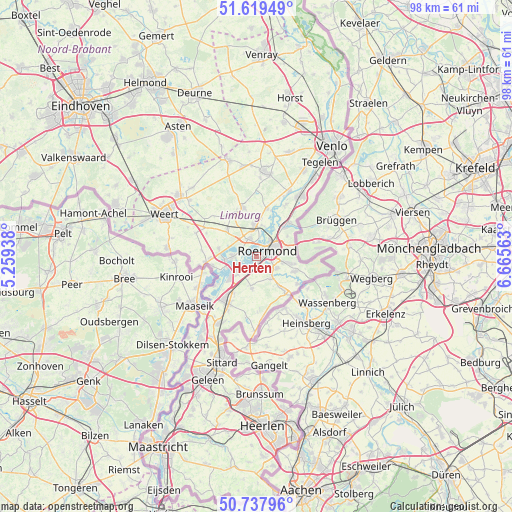
| Upper-left | 51.61949°, | 5.25938° |
| Center: | 51.18083°, | 5.9625° |
| Lower-right: | 50.73796°, | 6.66563° |
| Map W x H: | 98×98 km | = 60.9×60.9mi |
| max Lat: | 53.48025° ⇑91.6% North |
| Herten: | 51.18083° |
| min Lat: | ⇓8.4% South 50.76917° |
| min Long | Herten | max Long |
| 3.38611° | 5.9625° | 7.16528° |
| W 69%⇐ | ⇒31% E |
Elevation
Elevation of Herten is 23 m = 75 ft, and this is 8 m = 26 ft above average elevation for this country.
| Max E: |
203 m = 666 ft | 17.9% |
| Herten | 23 m 75 ft | |
| Avg. | 15 m = 49 ft | |
Min E: |
-6 m = -20 ft | 82.1% |
See also: Netherlands elevation on elevation.city.
Geographical zone
Herten is located in North temperate zone (between Tropic of Cancer and the Arctic Circle). Distance of this North polar circle is 1710.4 km =1062.8 mi to North.| Distance of | km | miles | from Herten |
|---|---|---|---|
| North Pole | 4316.3 | 2682 | to North |
| Arctic Circle | 1710.4 | 1062.8 | to North |
| Tropic Cancer | 3084.9 | 1916.9 | to South |
| Equator | 5690.8 | 3536.1 | to South |


Nearby cities:
15 places around Herten: (largest is in red/bold)
• Asenray
6.2 km =3.9 mi,  76°
76°
• Beegden
3.1 km =1.9 mi,  287°
287°
• Brachterbeek
5.5 km =3.4 mi,  227°
227°
• Haelen
6.1 km =3.8 mi,  356°
356°
• Heel
4.7 km =2.9 mi,  267°
267°
• Kitskensberg
3.1 km =1.9 mi,  108°
108°
• Leeuwen
4.1 km =2.5 mi,  37°
37°
• Linne
3.3 km =2.1 mi,  209°
209°
• Maasbracht
7 km =4.3 mi, 229°
• Melick
4.5 km =2.8 mi,  122°
122°
• Merum
0.9 km =0.6 mi,  193°
193°
• Montfort
6.2 km =3.9 mi, 189°
• Roermond
2.3 km =1.4 mi,  49°
49°
• Sint Odiliënberg
4.9 km =3 mi,  147°
147°
• Wessem
6.1 km =3.8 mi,  247°
247°
Sources, notices
• [Note1] Compared only with cities in Netherlands existing in our database
• [Src1] Map data: © OpenStreetMap contributors (CC-BY-SA)
• [Src2] Other city data from geonames.org with taken over terms of usage.
• [Src3] Geographical zone / Annual Mean Temperature by Robert A. Rohde @ Wikipedia
