Haelen geodata
Haelen (Limburg) is a populated place; located in Netherlands in Europe/Amsterdam (GMT+2) time zone. With population of 9,935 people, there are 290 cities with bigger population in this country. Compared to other cities in Netherlands, 90.8% of cities are located further ↑North; 68.5% of cities are located further ←West and 84.6% of cities have lower elevation than Haelen. Note1


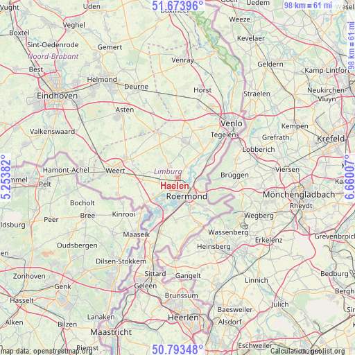
Haelen GPS coordinates[2]
51° 14' 8.988" North, 5° 57' 24.984" East
| Map corner | latitude | longitude |
|---|---|---|
| Upper-left | 51.67396°, | 5.25382° |
| Center: | 51.23583°, | 5.95694° |
| Lower-right: | 50.79348°, | 6.66007° |
| Map W x H: | 97.9×97.9 km | = 60.8×60.8mi |
| max Lat: | 53.48025° ⇑90.8% North |
| Haelen: | 51.23583° |
| min Lat: | ⇓9.2% South 50.76917° |
| min Long | Haelen | max Long |
| 3.38611° | 5.95694° | 7.16528° |
| W 68.5%⇐ | ⇒31.5% E |
Elevation
Elevation of Haelen is 26 m = 85 ft, and this is 11 m = 36 ft above average elevation for this country.
| Max E: |
203 m = 666 ft | 15.4% |
| Haelen | 26 m 85 ft | |
| Avg. | 15 m = 49 ft | |
Min E: |
-6 m = -20 ft | 84.6% |
See also: Netherlands elevation on elevation.city.
Geographical zone
Haelen is located in North temperate zone (between Tropic of Cancer and the Arctic Circle). Distance of this North polar circle is 1704.3 km =1059 mi to North.| Distance of | km | miles | from Haelen |
|---|---|---|---|
| North Pole | 4310.2 | 2678.2 | to North |
| Arctic Circle | 1704.3 | 1059 | to North |
| Tropic Cancer | 3091 | 1920.7 | to South |
| Equator | 5696.9 | 3539.9 | to South |


Nearby cities:
15 places around Haelen: (largest is in red/bold)
• Asenray
7.9 km =4.9 mi,  126°
126°
• Beegden
5.8 km =3.6 mi,  206°
206°
• Beesel
6.8 km =4.2 mi,  57°
57°
• Boukoul
6.7 km =4.2 mi,  109°
109°
• Egchel
8.8 km =5.5 mi,  6°
6°
• Heel
7.7 km =4.8 mi, 214°
• Heide
6 km =3.7 mi,  84°
84°
• Herten
6.1 km =3.8 mi,  176°
176°
• Heythuysen
4.4 km =2.7 mi,  291°
291°
• Kesseleik
6.6 km =4.1 mi,  44°
44°
• Kitskensberg
7.8 km =4.8 mi,  155°
155°
• Leeuwen
4.1 km =2.5 mi, 134°
• Leveroy
7.8 km =4.8 mi,  280°
280°
• Merum
7 km =4.3 mi, 178°
• Roermond
5.1 km =3.2 mi, 155°
Sources, notices
• [Note1] Compared only with cities in Netherlands existing in our database
• [Src1] Map data: © OpenStreetMap contributors (CC-BY-SA)
• [Src2] Other city data from geonames.org with taken over terms of usage.
• [Src3] Geographical zone / Annual Mean Temperature by Robert A. Rohde @ Wikipedia
