Heer geodata
Heer (Limburg) is a section of populated place; located in Netherlands in Europe/Amsterdam (GMT+2) time zone. With population of 7,615 people, there are 344 cities with bigger population in this country. Compared to other cities in Netherlands, 98.6% of cities are located further ↑North; 53.3% of cities are located further ←West and 94% of cities have lower elevation than Heer. Note1


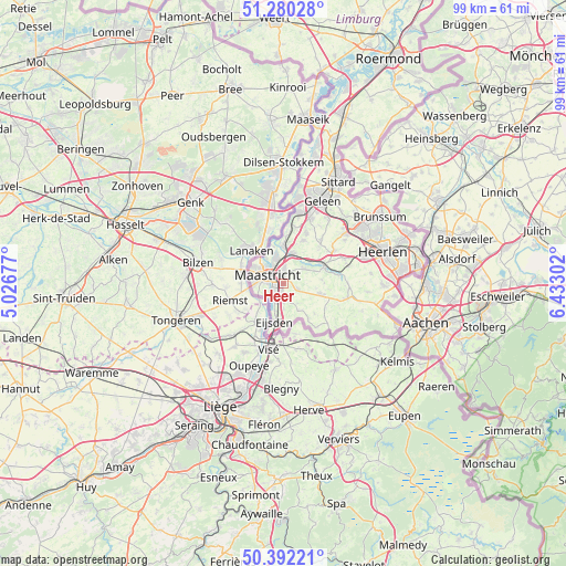
Heer GPS coordinates[2]
50° 50' 18.096" North, 5° 43' 47.604" East
| Map corner | latitude | longitude |
|---|---|---|
| Upper-left | 51.28028°, | 5.02677° |
| Center: | 50.83836°, | 5.72989° |
| Lower-right: | 50.39221°, | 6.43302° |
| Map W x H: | 98.7×98.7 km | = 61.3×61.3mi |
| max Lat: | 53.48025° ⇑98.6% North |
| Heer: | 50.83836° |
| min Lat: | ⇓1.4% South 50.76917° |
| min Long | Heer | max Long |
| 3.38611° | 5.72989° | 7.16528° |
| W 53.3%⇐ | ⇒46.7% E |
Elevation
Elevation of Heer is 58 m = 190 ft, and this is 43 m = 141 ft above average elevation for this country.
| Max E: |
203 m = 666 ft | 6% |
| Heer | 58 m 190 ft | |
| Avg. | 15 m = 49 ft | |
Min E: |
-6 m = -20 ft | 94% |
See also: Netherlands elevation on elevation.city.
Geographical zone
Heer is located in North temperate zone (between Tropic of Cancer and the Arctic Circle). Distance of this North polar circle is 1748.5 km =1086.5 mi to North.| Distance of | km | miles | from Heer |
|---|---|---|---|
| North Pole | 4354.4 | 2705.7 | to North |
| Arctic Circle | 1748.5 | 1086.5 | to North |
| Tropic Cancer | 3046.8 | 1893.2 | to South |
| Equator | 5652.7 | 3512.4 | to South |


Nearby cities:
15 places around Heer: (largest is in red/bold)
• Amby
2.7 km =1.7 mi,  3°
3°
• Belfort
5 km =3.1 mi,  281°
281°
• Berg
4.6 km =2.9 mi,  55°
55°
• Biesland
3.8 km =2.4 mi,  274°
274°
• De Heeg
1.6 km =1 mi,  197°
197°
• Eckelrade
4.2 km =2.6 mi,  144°
144°
• Gronsveld
3.1 km =1.9 mi,  179°
179°
• Heugem
1.9 km =1.2 mi,  233°
233°
• Limmel
3.6 km =2.2 mi,  333°
333°
• Maastricht
3.1 km =1.9 mi,  291°
291°
• Oost
4.9 km =3 mi, 196°
• Rijckholt
4.4 km =2.7 mi, 178°
• Rothem
4.3 km =2.7 mi,  8°
8°
• Scharn
1.3 km =0.8 mi, 10°
• Wolder
5 km =3.1 mi, 268°
Sources, notices
• [Note1] Compared only with cities in Netherlands existing in our database
• [Src1] Map data: © OpenStreetMap contributors (CC-BY-SA)
• [Src2] Other city data from geonames.org with taken over terms of usage.
• [Src3] Geographical zone / Annual Mean Temperature by Robert A. Rohde @ Wikipedia
