Gronsveld geodata
Gronsveld (Limburg) is a populated place; located in Netherlands in Europe/Amsterdam (GMT+2) time zone. With population of 2,380 people, there are 869 cities with bigger population in this country. Compared to other cities in Netherlands, 99.2% of cities are located further ↑North; 53.4% of cities are located further ←West and 94.6% of cities have lower elevation than Gronsveld. Note1


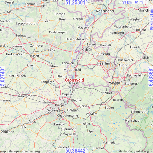
Gronsveld GPS coordinates[2]
50° 48' 38.988" North, 5° 43' 50.016" East
| Map corner | latitude | longitude |
|---|---|---|
| Upper-left | 51.25301°, | 5.02743° |
| Center: | 50.81083°, | 5.73056° |
| Lower-right: | 50.36442°, | 6.43368° |
| Map W x H: | 98.8×98.8 km | = 61.4×61.4mi |
| max Lat: | 53.48025° ⇑99.2% North |
| Gronsveld: | 50.81083° |
| min Lat: | ⇓0.8% South 50.76917° |
| min Long | Gronsveld | max Long |
| 3.38611° | 5.73056° | 7.16528° |
| W 53.4%⇐ | ⇒46.6% E |
Elevation
Elevation of Gronsveld is 62 m = 203 ft, and this is 47 m = 154 ft above average elevation for this country.
| Max E: |
203 m = 666 ft | 5.4% |
| Gronsveld | 62 m 203 ft | |
| Avg. | 15 m = 49 ft | |
Min E: |
-6 m = -20 ft | 94.6% |
See also: Netherlands elevation on elevation.city.
Geographical zone
Gronsveld is located in North temperate zone (between Tropic of Cancer and the Arctic Circle). Distance of this North polar circle is 1751.5 km =1088.3 mi to North.| Distance of | km | miles | from Gronsveld |
|---|---|---|---|
| North Pole | 4357.4 | 2707.6 | to North |
| Arctic Circle | 1751.5 | 1088.3 | to North |
| Tropic Cancer | 3043.7 | 1891.3 | to South |
| Equator | 5649.6 | 3510.5 | to South |


Nearby cities:
15 places around Gronsveld: (largest is in red/bold)
• Amby
5.7 km =3.5 mi,  1°
1°
• Banholt
5.9 km =3.7 mi,  112°
112°
• Biesland
5.1 km =3.2 mi,  311°
311°
• De Heeg
1.6 km =1 mi,  341°
341°
• Eckelrade
2.5 km =1.6 mi,  98°
98°
• Eijsden
3.5 km =2.2 mi,  194°
194°
• Heer
3.1 km =1.9 mi,  359°
359°
• Heugem
2.5 km =1.6 mi,  319°
319°
• Maastricht
5.1 km =3.2 mi, 324°
• Mheer
5.5 km =3.4 mi,  128°
128°
• Oost
2.2 km =1.4 mi,  220°
220°
• Rijckholt
1.3 km =0.8 mi,  175°
175°
• Scharn
4.4 km =2.7 mi, 2°
• Sint Geertruid
2.9 km =1.8 mi,  122°
122°
• Wolder
5.8 km =3.6 mi,  300°
300°
Sources, notices
• [Note1] Compared only with cities in Netherlands existing in our database
• [Src1] Map data: © OpenStreetMap contributors (CC-BY-SA)
• [Src2] Other city data from geonames.org with taken over terms of usage.
• [Src3] Geographical zone / Annual Mean Temperature by Robert A. Rohde @ Wikipedia
