Maastricht geodata
Maastricht (Limburg) is a seat of a first-order administrative division; located in Netherlands in Europe/Amsterdam (GMT+2) time zone. With population of 122,378 people, there are 18 cities with bigger population in this country. Compared to other cities in Netherlands, 98.4% of cities are located further ↑North; 51.4% of cities are located further ←West and 93.8% of cities have lower elevation than Maastricht. Note1


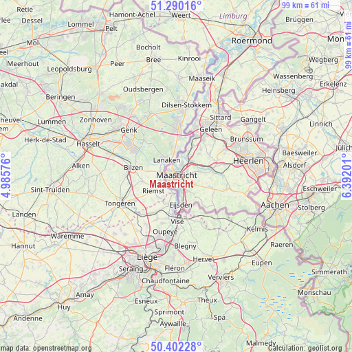
Maastricht GPS coordinates[2]
50° 50' 53.988" North, 5° 41' 20.004" East
| Map corner | latitude | longitude |
|---|---|---|
| Upper-left | 51.29016°, | 4.98576° |
| Center: | 50.84833°, | 5.68889° |
| Lower-right: | 50.40228°, | 6.39201° |
| Map W x H: | 98.7×98.7 km | = 61.3×61.3mi |
| max Lat: | 53.48025° ⇑98.4% North |
| Maastricht: | 50.84833° |
| min Lat: | ⇓1.6% South 50.76917° |
| min Long | Maastricht | max Long |
| 3.38611° | 5.68889° | 7.16528° |
| W 51.4%⇐ | ⇒48.6% E |
Elevation
Elevation of Maastricht is 56 m = 184 ft, and this is 41 m = 135 ft above average elevation for this country.
| Max E: |
203 m = 666 ft | 6.2% |
| Maastricht | 56 m 184 ft | |
| Avg. | 15 m = 49 ft | |
Min E: |
-6 m = -20 ft | 93.8% |
See also: Maastricht elevation on elevation.city.
Geographical zone
Maastricht is located in North temperate zone (between Tropic of Cancer and the Arctic Circle). Distance of this North polar circle is 1747.4 km =1085.8 mi to North.| Distance of | km | miles | from Maastricht |
|---|---|---|---|
| North Pole | 4353.3 | 2705 | to North |
| Arctic Circle | 1747.4 | 1085.8 | to North |
| Tropic Cancer | 3047.9 | 1893.9 | to South |
| Equator | 5653.8 | 3513.1 | to South |


Nearby cities:
15 places around Maastricht: (largest is in red/bold)
• Amby
3.4 km =2.1 mi,  63°
63°
• Belfort
2 km =1.2 mi,  265°
265°
• Biesland
1.2 km =0.7 mi,  228°
228°
• Borgharen
3.2 km =2 mi,  358°
358°
• De Heeg
3.6 km =2.2 mi,  137°
137°
• Gronsveld
5.1 km =3.2 mi, 144°
• Heer
3.1 km =1.9 mi,  111°
111°
• Heugem
2.6 km =1.6 mi,  149°
149°
• Limmel
2.5 km =1.6 mi,  31°
31°
• Malberg
2.9 km =1.8 mi,  302°
302°
• Oud-Caberg
2.6 km =1.6 mi,  317°
317°
• Pottenberg
2.3 km =1.4 mi,  278°
278°
• Rothem
4.7 km =2.9 mi,  48°
48°
• Scharn
3.1 km =1.9 mi,  86°
86°
• Wolder
2.4 km =1.5 mi,  239°
239°
Sources, notices
• [Note1] Compared only with cities in Netherlands existing in our database
• [Src1] Map data: © OpenStreetMap contributors (CC-BY-SA)
• [Src2] Other city data from geonames.org with taken over terms of usage.
• [Src3] Geographical zone / Annual Mean Temperature by Robert A. Rohde @ Wikipedia
