Groot-Ammers geodata
Groot-Ammers (South Holland) is a populated place; located in Netherlands in Europe/Amsterdam (GMT+2) time zone. With population of 3,305 people, there are 710 cities with bigger population in this country. Compared to other cities in Netherlands, 56% of cities are located further ↑North; 78.6% of cities are located further →East and 98.2% of cities have higher elevation than Groot-Ammers. Note1


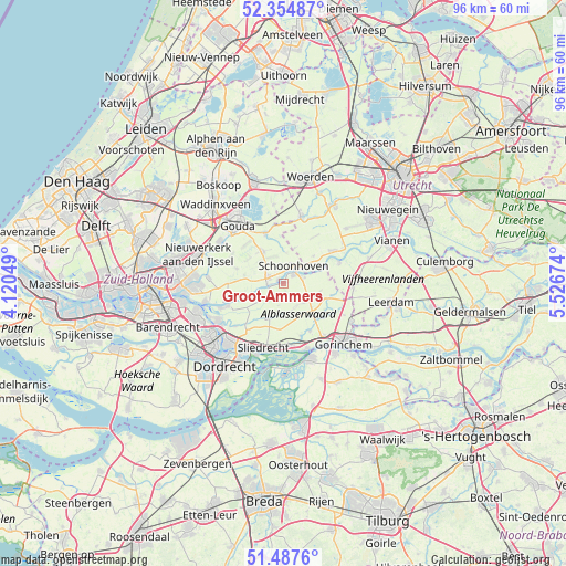
Groot-Ammers GPS coordinates[2]
51° 55' 23.988" North, 4° 49' 24.996" East
| Map corner | latitude | longitude |
|---|---|---|
| Upper-left | 52.35487°, | 4.12049° |
| Center: | 51.92333°, | 4.82361° |
| Lower-right: | 51.4876°, | 5.52674° |
| Map W x H: | 96.4×96.4 km | = 59.9×59.9mi |
| max Lat: | 53.48025° ⇑56% North |
| Groot-Ammers: | 51.92333° |
| min Lat: | ⇓44% South 50.76917° |
| min Long | Groot-Ammers | max Long |
| 3.38611° | 4.82361° | 7.16528° |
| W 21.4%⇐ | ⇒78.6% E |
Elevation
Elevation of Groot-Ammers is -2 m = -7 ft, and this is 17 m = 56 ft below average elevation for this country.
| Max E: |
203 m = 666 ft | 98.2% |
| Avg. | 15 m = 49 ft | |
| Groot-Ammers | -2 m = -7 ft | |
Min E: |
-6 m = -20 ft | 1.8% |
See also: Netherlands elevation on elevation.city.
Geographical zone
Groot-Ammers is located in North temperate zone (between Tropic of Cancer and the Arctic Circle). Distance of this North polar circle is 1627.8 km =1011.5 mi to North.| Distance of | km | miles | from Groot-Ammers |
|---|---|---|---|
| North Pole | 4233.7 | 2630.7 | to North |
| Arctic Circle | 1627.8 | 1011.5 | to North |
| Tropic Cancer | 3167.4 | 1968.1 | to South |
| Equator | 5773.3 | 3587.4 | to South |


Nearby cities:
15 places around Groot-Ammers: (largest is in red/bold)
• Ammerstol
1.1 km =0.7 mi,  293°
293°
• Bergstoep
2.7 km =1.7 mi,  268°
268°
• Berkenwoude
8.4 km =5.2 mi, 286°
• Bleskensgraaf
6.3 km =3.9 mi,  206°
206°
• Cabauw
6.9 km =4.3 mi,  48°
48°
• Giessenburg
9.3 km =5.8 mi,  150°
150°
• Haastrecht
9.2 km =5.7 mi,  339°
339°
• Liesveld
1.2 km =0.7 mi,  29°
29°
• Nieuwpoort
3.3 km =2.1 mi,  65°
65°
• Noordeloos
8.4 km =5.2 mi,  105°
105°
• Opperduit
8.1 km =5 mi,  250°
250°
• Schoonhoven
3.2 km =2 mi, 32°
• Stein
9.3 km =5.8 mi, 342°
• Stolwijk
6.5 km =4 mi,  327°
327°
• Vlist
6.3 km =3.9 mi,  357°
357°
Sources, notices
• [Note1] Compared only with cities in Netherlands existing in our database
• [Src1] Map data: © OpenStreetMap contributors (CC-BY-SA)
• [Src2] Other city data from geonames.org with taken over terms of usage.
• [Src3] Geographical zone / Annual Mean Temperature by Robert A. Rohde @ Wikipedia
