Stolwijk geodata
Stolwijk (South Holland) is a populated place; located in Netherlands in Europe/Amsterdam (GMT+2) time zone. With population of 3,730 people, there are 634 cities with bigger population in this country. Compared to other cities in Netherlands, 53.1% of cities are located further ↑North; 81.1% of cities are located further →East and 96.1% of cities have higher elevation than Stolwijk. Note1


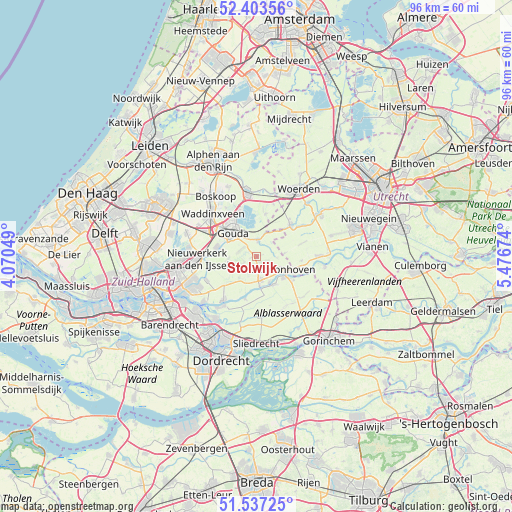
Stolwijk GPS coordinates[2]
51° 58' 21" North, 4° 46' 24.996" East
| Map corner | latitude | longitude |
|---|---|---|
| Upper-left | 52.40356°, | 4.07049° |
| Center: | 51.9725°, | 4.77361° |
| Lower-right: | 51.53725°, | 5.47674° |
| Map W x H: | 96.3×96.3 km | = 59.8×59.8mi |
| max Lat: | 53.48025° ⇑53.1% North |
| Stolwijk: | 51.9725° |
| min Lat: | ⇓46.9% South 50.76917° |
| min Long | Stolwijk | max Long |
| 3.38611° | 4.77361° | 7.16528° |
| W 18.9%⇐ | ⇒81.1% E |
Elevation
Elevation of Stolwijk is -1 m = -3 ft, and this is 16 m = 52 ft below average elevation for this country.
| Max E: |
203 m = 666 ft | 96.1% |
| Avg. | 15 m = 49 ft | |
| Stolwijk | -1 m = -3 ft | |
Min E: |
-6 m = -20 ft | 3.9% |
See also: Netherlands elevation on elevation.city.
Geographical zone
Stolwijk is located in North temperate zone (between Tropic of Cancer and the Arctic Circle). Distance of this North polar circle is 1622.4 km =1008.1 mi to North.| Distance of | km | miles | from Stolwijk |
|---|---|---|---|
| North Pole | 4228.3 | 2627.3 | to North |
| Arctic Circle | 1622.4 | 1008.1 | to North |
| Tropic Cancer | 3172.9 | 1971.5 | to South |
| Equator | 5778.8 | 3590.8 | to South |


Nearby cities:
15 places around Stolwijk: (largest is in red/bold)
• Ammerstol
5.5 km =3.4 mi,  154°
154°
• Bergstoep
5.6 km =3.5 mi,  172°
172°
• Berkenwoude
5.5 km =3.4 mi,  236°
236°
• Bloemendaal
8.3 km =5.2 mi,  319°
319°
• Cabauw
8.6 km =5.3 mi,  96°
96°
• Driebruggen
8.2 km =5.1 mi,  12°
12°
• Gouda
6.6 km =4.1 mi, 317°
• Gouderak
6.7 km =4.2 mi,  281°
281°
• Groot-Ammers
6.5 km =4 mi, 147°
• Haastrecht
3.1 km =1.9 mi,  3°
3°
• Liesveld
6 km =3.7 mi,  138°
138°
• Nieuwpoort
7.6 km =4.7 mi,  122°
122°
• Schoonhoven
5.8 km =3.6 mi, 118°
• Stein
3.5 km =2.2 mi, 9°
• Vlist
3.2 km =2 mi,  75°
75°
Sources, notices
• [Note1] Compared only with cities in Netherlands existing in our database
• [Src1] Map data: © OpenStreetMap contributors (CC-BY-SA)
• [Src2] Other city data from geonames.org with taken over terms of usage.
• [Src3] Geographical zone / Annual Mean Temperature by Robert A. Rohde @ Wikipedia
