Bleskensgraaf geodata
Bleskensgraaf (South Holland) is a populated place; located in Netherlands in Europe/Amsterdam (GMT+2) time zone. With population of 2,800 people, there are 789 cities with bigger population in this country. Compared to other cities in Netherlands, 60.3% of cities are located further ↑North; 80.5% of cities are located further →East and 91.3% of cities have higher elevation than Bleskensgraaf. Note1


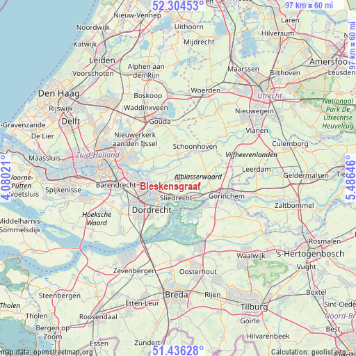
Bleskensgraaf GPS coordinates[2]
51° 52' 21" North, 4° 46' 59.988" East
| Map corner | latitude | longitude |
|---|---|---|
| Upper-left | 52.30453°, | 4.08021° |
| Center: | 51.8725°, | 4.78333° |
| Lower-right: | 51.43628°, | 5.48646° |
| Map W x H: | 96.5×96.5 km | = 60×60mi |
| max Lat: | 53.48025° ⇑60.3% North |
| Bleskensgraaf: | 51.8725° |
| min Lat: | ⇓39.7% South 50.76917° |
| min Long | Bleskensgraaf | max Long |
| 3.38611° | 4.78333° | 7.16528° |
| W 19.5%⇐ | ⇒80.5% E |
Elevation
Elevation of Bleskensgraaf is 0 m = 0 ft, and this is 15 m = 49 ft below average elevation for this country.
| Max E: |
203 m = 666 ft | 91.3% |
| Avg. | 15 m = 49 ft | |
| Bleskensgraaf | 0 m = 0 ft | |
Min E: |
-6 m = -20 ft | 8.7% |
See also: Netherlands elevation on elevation.city.
Geographical zone
Bleskensgraaf is located in North temperate zone (between Tropic of Cancer and the Arctic Circle). Distance of this North polar circle is 1633.5 km =1015 mi to North.| Distance of | km | miles | from Bleskensgraaf |
|---|---|---|---|
| North Pole | 4239.4 | 2634.2 | to North |
| Arctic Circle | 1633.5 | 1015 | to North |
| Tropic Cancer | 3161.8 | 1964.7 | to South |
| Equator | 5767.7 | 3583.9 | to South |


Nearby cities:
15 places around Bleskensgraaf: (largest is in red/bold)
• Alblasserdam
8.4 km =5.2 mi,  264°
264°
• Ammerstol
6.4 km =4 mi,  15°
15°
• Bergstoep
5.6 km =3.5 mi,  0°
0°
• Boven-Hardinxveld
8.7 km =5.4 mi,  128°
128°
• De Peulen
6 km =3.7 mi,  154°
154°
• Giessenburg
7.7 km =4.8 mi,  108°
108°
• Giessendam
5.7 km =3.5 mi,  140°
140°
• Groot-Ammers
6.3 km =3.9 mi,  26°
26°
• Liesveld
7.5 km =4.7 mi, 26°
• Neder-Hardinxveld
6.9 km =4.3 mi, 134°
• Nieuw-Lekkerland
6.9 km =4.3 mi,  285°
285°
• Opperduit
5.7 km =3.5 mi,  301°
301°
• Papendrecht
8 km =5 mi,  235°
235°
• Sliedrecht
5.8 km =3.6 mi,  184°
184°
• Wijngaarden
3.4 km =2.1 mi,  205°
205°
Sources, notices
• [Note1] Compared only with cities in Netherlands existing in our database
• [Src1] Map data: © OpenStreetMap contributors (CC-BY-SA)
• [Src2] Other city data from geonames.org with taken over terms of usage.
• [Src3] Geographical zone / Annual Mean Temperature by Robert A. Rohde @ Wikipedia
